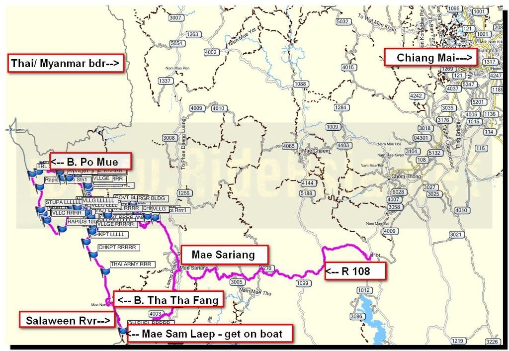
"THE" most north trail from the Salaween River mapped into Thailand

Jeab offers us some food and coffee - she won't accept money but we manage to make a donation to the school


8391494020_ae08ca59cc_b.jpg
 
We're not sure if Alex disturbed an ants nest from a tree or was irritated by a tree or plant, but he came out in blotches and a nasty rash


8390410471_f7e896fcce_b.jpg


Luckily Jeab and some students swabbed him down


8391493712_e3b75136c6_b.jpg


A few hours and he was all better, Jeab thinks it was ants


8390409991_aebd72af76_b.jpg
 
Some of the local guys were knocking the whiskey back, they actually were very knowledgeable about distances to the next villages


8390410285_8ced204716_b.jpg


8391492936_85f6514337_b.jpg
 
A very cold night's sleep, must have been 10C or less, I had 4 layers on, iflatable Thermarest Neo Air mattress under me and a space blanket at the ready. Note - An inflatable mattress under you is an excellent insulator from the cold in a hammock.


8390409677_aec9c63feb_b.jpg


The next morning some eggs and rice, said goodbye to Jeab and of south east


8390409275_21f6b6e031_b.jpg


8390409571_a6201ff43c_b.jpg


8391492434_a9e4ca42e7_b.jpg
 
The next task was to find the trail to the village Ban Pho Sur, this wasn't so easy, many river crossings and trails off at several directions


8391493594_dfc05514cd_b.jpg


The locals along the way were invaluable for directions without their help we might not have made it


8390408725_c80e8d6c7e_b.jpg


8390408601_5fa8984f79_b.jpg
 
Note - From the village of Ban Cho Si Doe Nuea, its possible in dry season to drive a pickup in the rivers all the way to Mae Sariang, it winds around and meets up with the walking/ motorcycle trail
 
The trails are now easier, 100's of water crossings through rivers, 50km further SE we get to Ban Pho Sur


8391491300_34d9359769_b.jpg


8390408081_5e38dc085d_b.jpg


Then a few KM's more and we're back at the junction that will take you to the Oro Forest Ranger HQ -- we've linked it all up!


8391490970_b2b6aa8c8a_b.jpg


Another ranger station near the junction


8390407633_95ff1111e6_b.jpg


8391491458_41bc07031d_b.jpg


Some of the areas in constant shade were still nasty


8390407521_7ec8e47273_b.jpg
 
SE of Ban Pho Sur the trails get easier and easier, lots of pick up traffic to be wary of at its the only access road to all the villages


8390407389_bd646d9978_b.jpg


Everything going well time-wise, we headed straight for Mae Sam Laep to get the truck, get the bikes in & head back to Chiang Mai, a very successful mission in the end (with a bit of luck).


map all.jpg
 
A few more photo's from a different camera


Never worked out what they were doing here
'

8391006459_8ccff7df39_b.jpg


A few Mae Sam Laep photo's


8392090520_5a1a273537_b.jpg


8391006091_6f0a41ab5d_b.jpg


8392090428_33a53ea450_b.jpg


8391006381_5777eb4457_b.jpg
 
Some great photos and exploring done there Phil & Alex
 
Gradient graphs of the trail from the Salaween River SE towards Mae Sariang.


1st graph shows the gradients from the Salaween River to 24 km SE, so to east of Ban Po Mue to Ban Cho Si Doe Nuea (school where we slept)


View attachment 13912


2nd graph below shows the gradients from Ban Cho Si Doe Nuea , 100 km SE to Mae Sariang


View attachment 13913
 
2 mountain biker's from Chiang Mai intrigued by this trail are going to attempt it this Friday, i've given them the tracks and waypoints. They are very experience in trail exploring and looking at the initial gradients, they estimate they will have to carry their bikes on the first 8 km east towards Ban Po Mue most of the way.


Check out the gradient from the Salaween River 4km eastwards, they're sure they'll be carrying their bikes on this section


13912d1359271022-most-north-trail-salaween-river-mapped-into-thailand-rvr-po-mue-area-elevation.jpg


It was very interesting being involved in their planning for this trip, number 1 concern for them was where they could replenish drinking water, staying light, they can only carry 3 liters of drinking water each. They preferred the idea of villages to get drinking water over replenishing from streams and were interested as to where the first source of sealed drinking water could be purchased. For me village rain/ spring water has never been a problem, streams i'm a little bit more careful as you don't know what's happening up stream, so I bring a small, clear bottle to inspect the water filter product water before I add it to my drinking water bladder.


Bumpy, hilly terrain, they estimated their average speed would be 15-20 km/h, flat ground they can average up to 30 km/h.


Second and third concerns were where they could get food and villages to sleep. Trying to keep the bike light, they only want to bring sleeping bags and no camping gear.


Wishing them good luck for this on bicycles, they say they'll do a report for us.
 
I think they'll love it.
You should tell them to follow the singletrack, not the 4wd track, on that section through the streams
 
Phil, thanks for all the help and advice. Your descriptions and photos are amazing. Whoever said "Adventure is Dead" needs to read the trip reports here; yours and others.
We're leaving on Thursday for Mae Sariang. Friday we'll take the boat upriver. We'll post a report in the MTB subform with a link here when we get back.
 
Really looking forward to your report on this trip on mountain bikes Jeff, as it will be the first we have. I suppose especially it being on such a new trail that most don't even knows exits, good luck, you still have my offer of if you get stuck I'll come get you.


Phil, thanks for all the help and advice. Your descriptions and photos are amazing. Whoever said "Adventure is Dead" needs to read the trip reports here; yours and others.
We're leaving on Thursday for Mae Sariang. Friday we'll take the boat upriver. We'll post a report in the MTB subform with a link here when we get back.
 
Andrew / Jeff - Alex makes a good point here, always follow the single track trail if there's a choice between that and the 4wd truck track (ie the 2 divert from each other). If they split it means that the 4wd truck track is going into the river where they'll be huge rocks, the other way (single track) will be more suitable.


I think they'll love it.
You should tell them to follow the singletrack, not the 4wd track, on that section through the streams
 
The adventure mountain biker's are back from this area & hopefully Jeff is going to tell the story of what happened. We have learned a lot from their trip.
 
Phil was probably the first to ride these trails and, more likely, the last.
We've posted a report of our attempt to do this on mountain bikes here -- http://www.rideasia.net/motorcycle-...mae-sarieng-salween-river-loop.html#post24813
This trip can probably still be done in reverse and then trying to get a boat down river, or by going up the Salween in several stages. Either way it adds a substantial amount of time to the trip, possibly days.

The adventure mountain biker's are back from this area & hopefully Jeff is going to tell the story of what happened. We have learned a lot from their trip.
 
Apparently this area way north west of Mae Sariang on the Salaween River ( Ban Po Mue) is a restricted, sensitive area & we shouldn't have been there. This would explain why our map is the ONLY non-Thai Military map with this trail data. We had a Thai Government Park Ranger, driving the boat and presumed because of that we were ok. We've been told if the Army had known were were headed there they would have refused permission.


More on the sequence of events in the thread below:

http://www.rideasia.net/motorcycle-...mae-sarieng-salween-river-loop.html#post24823
 
quote_icon.png
Originally Posted by el jefe
and, more likely, the last.


Looking forward to hearing your report when you try to get permission from the Thai military!


Now you see, this is where I actually go read your report to find out why, which turns out to be a great story too.
Cheers
 
Back
Top Bottom