You are using an out of date browser. It may not display this or other websites correctly.
You should upgrade or use an alternative browser.
You should upgrade or use an alternative browser.
"THE" most north trail from the Salaween River mapped into Thailand
- Thread starter KTMphil
- Start date
KTMphil
Senior member
It all started with looking at Google Maps satellite imagery of the Salaween River way north of Ban Tha Tha Fang. There is a trail north of Ban Tha Tha Fang that leads west towards Mae Sariang that some guys have done, we were looking for something way way north of there, LR knew there were a loads of refugee villages up there, so there had to be trails.
This caught my eye way north --- could this be the trail from the Salaween River we'd be looking for????
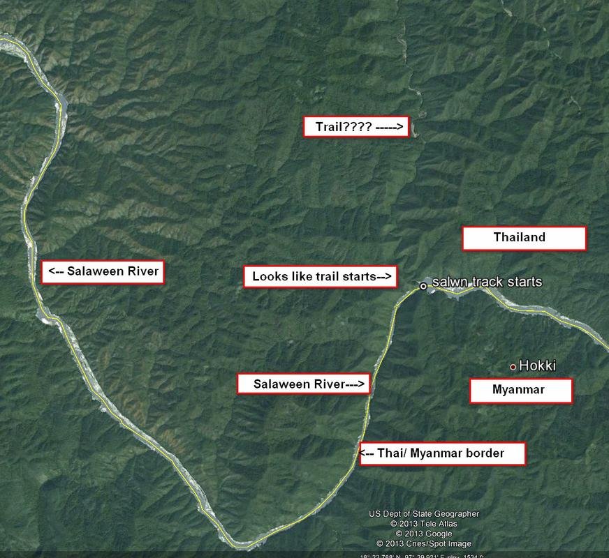
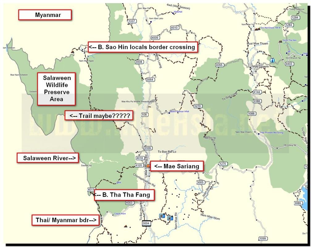
This caught my eye way north --- could this be the trail from the Salaween River we'd be looking for????


- Joined
- Aug 15, 2012
- Bikes
- KTM 613 EXC, BMW R90S & Dakar, MZ250, Norton 16H, Honda - 500 Fs & Xs, DRZs, XLs XRs CRFs CT110s etc
Keep 'em coming.
KTMphil
Senior member
The curiosity was unbearable, I showed Alex the satellite image print outs and explained what I thought, it got his juices flowing and we made a plan to go. LR said "I think that's just a river guys", more on who was right later.
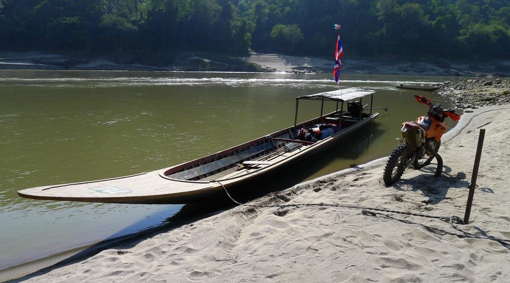
So a WR 250 F, a KTM 300 2-smoker, 100 liters of fuel, 30 liters of water, food and camping gear in the Vigo, off we head to Mae Sam Laep, 43km SW of Mae Sariang to try rent a boat for a few days.

So a WR 250 F, a KTM 300 2-smoker, 100 liters of fuel, 30 liters of water, food and camping gear in the Vigo, off we head to Mae Sam Laep, 43km SW of Mae Sariang to try rent a boat for a few days.

KTMphil
Senior member
KTMphil
Senior member
There's an adequate Guest house in Mae Sam Leap, almost opposite the steps down to the "harbor" - The Salaween GH co-ords:
N17.98093
E97.73896
or
N17 58.856
E97 44.338

300 bht, fan, cold shower & clean

Fantastic view looking west across the Salaween River into Myanmar


The Myanmar Military Checkpoint on the western side of the Salaween River, opposite Ban Mae Sam Laep

N17.98093
E97.73896
or
N17 58.856
E97 44.338

300 bht, fan, cold shower & clean

Fantastic view looking west across the Salaween River into Myanmar


The Myanmar Military Checkpoint on the western side of the Salaween River, opposite Ban Mae Sam Laep

KTMphil
Senior member
The Salaween Gh in Mae Sam Laep does also have fuel


KTMphil
Senior member
The next thing you have to do is find this man "Khow Sai". He is the man that can organize you a boat, he speaks good English (remember you're in Karen tribe region where many don't even speak Thai) and he can translate everything you need to the boat driver and negotiate a price. Motorcycle tour groups have been using him for years to organize boats & never the tourist-ripoff has been experienced with this guy, he's a good guy.
He's not just a tout on the dock, give him some respect.

A rule of thumb is that they charge 1,300 bht a day for boat use.
We wanted a boat for 4 days to stay with us, so we could do as much surveying as we could way north, he came back with a price of 5,000 bht which we accepted.
He's not just a tout on the dock, give him some respect.

A rule of thumb is that they charge 1,300 bht a day for boat use.
We wanted a boat for 4 days to stay with us, so we could do as much surveying as we could way north, he came back with a price of 5,000 bht which we accepted.
KTMphil
Senior member
Traditional Karen dress in Mae Sam Laep


Boat organized, the last hot food maybe for a while


Boat organized, the last hot food maybe for a while

KTMphil
Senior member
So boat organized, Khow Sai had an idea of where we wanted to go, next hurdle was to get clearance from the Thai Army. Way north there is a very sensitive area, very remote - no hospitals, no doctors, no telephone reception, no cars, no electricity, no police, no army etc..... if things went wrong, we could have a serious problem, only with refugee status scattered villages for assistance.
Khow Sai explained where we wanted to go with the bikes and it looked like a NO from the Army, which really dampened my spirits after all this effort.

I explained that we were leaving the pick up in Mae Sam Laep so we had to return which then got the Army officer thinking - he radioed his boss to ask permission

Khow Sai explained where we wanted to go with the bikes and it looked like a NO from the Army, which really dampened my spirits after all this effort.

I explained that we were leaving the pick up in Mae Sam Laep so we had to return which then got the Army officer thinking - he radioed his boss to ask permission

KTMphil
Senior member
He came out of the building ---- "OK"!!! - Fantastic!!!!
Our details were registered with the Army

Fuel, water, food, camping gear, bikes etc..... were then all taken down to the "harbor" and loaded onto the boat, we were nearly on our way.


Thai Army fast skiffs with huge Yamaha outboard engines


Pick nick by the river

Our details were registered with the Army

Fuel, water, food, camping gear, bikes etc..... were then all taken down to the "harbor" and loaded onto the boat, we were nearly on our way.


Thai Army fast skiffs with huge Yamaha outboard engines


Pick nick by the river

KTMphil
Senior member
Long tail boats in the "harbor"

Everything loaded and off north up the Salaween River


Our driver

Headed north - Myanmar on the left, Thailand on the right

River cargo


Everything loaded and off north up the Salaween River


Our driver

Headed north - Myanmar on the left, Thailand on the right

River cargo

KTMphil
Senior member
As you head north, there are several military checkpoints that you have to register with and explain your plans and get permission to proceed. You're in an area where people have no passports and no ID, things could get crazy very easily.

Fuel for sale on the Myanmar river bank

A Myanmar village


Thai Army look-out post


Fuel for sale on the Myanmar river bank

A Myanmar village


Thai Army look-out post

KTMphil
Senior member
We estimated we were driving into about 10-15 km/h for river current, the GPS showed us doing between 21-25 km/h over the ground, so these boats are doing 35 km/h through the water, very efficient.


Alex about to take a nap


Alex about to take a nap

KTMphil
Senior member
We have a waypoint in the GPS of where we want to get to on the river bank that matches the satellite imagery of what we think is the track. Pretty excited, we approach the river bank

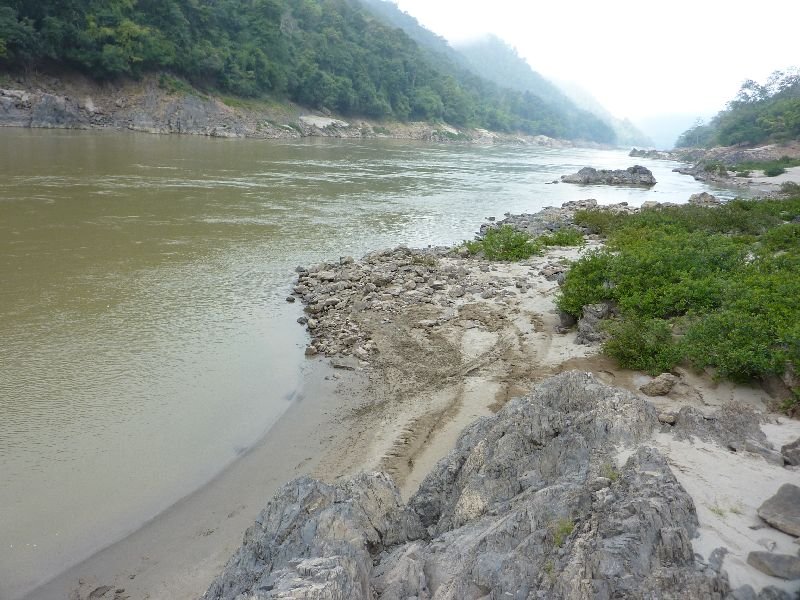
We get out and do a survey ...... doesnt look good, we can't see any trails along the side of the river

One option would be to ride up the river, but we have no idea of how deep etc......


We get out and do a survey ...... doesnt look good, we can't see any trails along the side of the river

One option would be to ride up the river, but we have no idea of how deep etc......

KTMphil
Senior member
Boat driver shakes his head and says there's NO trail there - LR was right

We ask the boar driver if he knows of any trails further north, he says there's none (more on that later - there is). He says 10km south there's some trails, so bikes back in the boat.


We ask the boar driver if he knows of any trails further north, he says there's none (more on that later - there is). He says 10km south there's some trails, so bikes back in the boat.

KTMphil
Senior member
Floating house on the Thai side

Back down stream


Long boat used to transport herds of buffalo that are farmed in the area


Back down stream


Long boat used to transport herds of buffalo that are farmed in the area

KTMphil
Senior member
10km south, we unload the bikes, it's now 3pm.

We decide to go for a 3 hour ride, try and link up to some trails we already have and leave all the gear in the boat. We tell the boat driver to stay there, we'll be back in 3 hours ("sam Shamung") - he says ok so off we go

Plenty of trails around, we do some good poking around


We got some good new data and linked it to existing trails, a productive afternoon
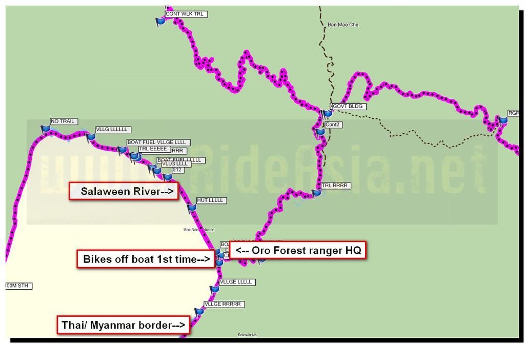

We decide to go for a 3 hour ride, try and link up to some trails we already have and leave all the gear in the boat. We tell the boat driver to stay there, we'll be back in 3 hours ("sam Shamung") - he says ok so off we go

Plenty of trails around, we do some good poking around


We got some good new data and linked it to existing trails, a productive afternoon

KTMphil
Senior member
Feeling like the day wasn't wasted, we return to the river bank to find our boat. We get there in the dark - no boat. That means no water, no food, no camping gear, where the hell has he gone??
Also no moon - so its pitch black

Lots of shouting and screaming, we listen but no reply, the boat isn't anywhere near, now what are we going to do? We see a light coming down the mountain and to our luck its a couple of guys from the ranger station, they say come up with us , we follow. We leave the bikes there in case the boat returns and he'll know where we are.
They feed us give us coffee and a room to sleep

Also no moon - so its pitch black

Lots of shouting and screaming, we listen but no reply, the boat isn't anywhere near, now what are we going to do? We see a light coming down the mountain and to our luck its a couple of guys from the ranger station, they say come up with us , we follow. We leave the bikes there in case the boat returns and he'll know where we are.
They feed us give us coffee and a room to sleep

KTMphil
Senior member
In our room - the map on the wall immediately catches our eye and we call the rangers guys in for a discussion

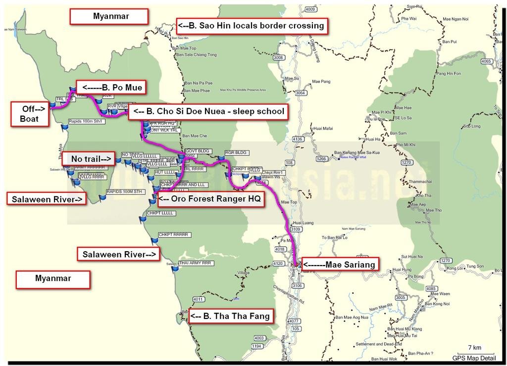
In Thai we talk about villages in the area and trails and get onto talking about trails further north (if the boat had been there we would never have been fortunate enough to be getting this information). The Rangers tell us that the locals had cut a trail from the river to a refugee village called Ban Po Mue, way way north. They say its only single track but doable all the way back to Mae Sariang ---- suddenly we have big grins om our face. "If" the boat comes back tomorrow thats where we headed.
We ask them if there are ANY more trails more north from the river that will link up to Mae Sariang, they say this is the most north trail, there are no more north from the river that link up passed this one.
Hopefully our destination tomorrow - Ban Po Mue ( Muer)

KTMphil
Senior member
Beds for the night in the Ranger HQ

What a view they have , here looking south down the Salaween River, Myanmar on the right side


What a view they have , here looking south down the Salaween River, Myanmar on the right side


KTMphil
Senior member
Next morning the rangers were kind enough to feed and water us

The guy on the right in the grey track suit is Kun Sing, one of the nicest, most professional Thai's i've ever met, we owe him huge for his generosity & vast knowledge, an amazing man.


The guy on the right in the grey track suit is Kun Sing, one of the nicest, most professional Thai's i've ever met, we owe him huge for his generosity & vast knowledge, an amazing man.


Lone Rider
Blokes Who Can
Fantastic stuff and great pictures as usual Phil. Have just converted all the tracks and waypoints so that it is ready to be included in the map and I emailed the stuff to the guy who is taking over all the map making stuff from me. He emailed me that the map should be back in an hour or so and be ready for the GPS as well as being able to load into Mapsource/BaseCamp.
KTMphil
Senior member
KTMphil
Senior member
Our boat arrives, the Rangers explain to the driver where the trail is , he doesn't want to go there, says he doesnt have enough diesel (its about 3 hours north of where we are by boat into the river current with rapids) and he doesnt know the river up there. We beg one of the Rangers who know the area to drive the boat and he agrees. After some hard talk, the driver/ boat owner reluctantly surrenders, basically he doesnt want to buy more fuel, we've already seen fuel for sale further north when looking for the non-existent trail.


KTMphil
Senior member
Off we go, this is now exciting shit, who knows how bad this ledge trail way up there will be.
Load everything back on and off we go

They bring the bikes much further aft in the boat now, the Salaween further north is nasty with lost of rapids and whirlpools.

Pulling in on the Myanmar side to get diesel

Curious Myanmar refugees

Alex in Myanmar having a chat

Our driver in the green sarong trying to act that there's no diesel, i tell him if he doesnt get diesel we're not going to pay him

That changes things and then the boat is filled with diesel

Load everything back on and off we go

They bring the bikes much further aft in the boat now, the Salaween further north is nasty with lost of rapids and whirlpools.

Pulling in on the Myanmar side to get diesel

Curious Myanmar refugees

Alex in Myanmar having a chat

Our driver in the green sarong trying to act that there's no diesel, i tell him if he doesnt get diesel we're not going to pay him

That changes things and then the boat is filled with diesel

KTMphil
Senior member
Our diesel power unit, probably a truck engine in its previous life

Drying produce

A couple of locals hear we headed north and hitch a ride with us


Drying produce

A couple of locals hear we headed north and hitch a ride with us

KTMphil
Senior member
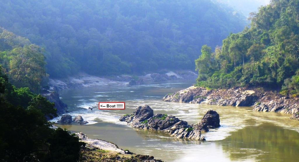
North up the Salaween river ---amazing scenery


KTMphil
Senior member
Our new driver, one of the Oro Forest Park Rangers, the river was nasty up here, rocks, rapids, whirlpools

Rapids ahead

Letting the locals off further north in Myamar


Rapids ahead

Letting the locals off further north in Myamar


KTMphil
Senior member
....more to come
KTMphil
Senior member
2 more hours of moving time north at 22 kts - so over 40km more north in the boat and we finally reach the landing which is about 8 km west of the refugee village of Ban Po Mue.

Everything looks ok so far, a quick survey looks like we can get the bikes off of the river bank, so time to unload everything

It has a real remote feel about it up here, kind of un-nerving in a way, once we're in that jungle we're on our own for sure


Everything looks ok so far, a quick survey looks like we can get the bikes off of the river bank, so time to unload everything

It has a real remote feel about it up here, kind of un-nerving in a way, once we're in that jungle we're on our own for sure

KTMphil
Senior member
At the top of the river bank there's one house - the locals there confirm that there's a ledge trail to Ban Po Mue and you can continue to Mae Sariang on single track

They show us which way to go

Alex and I both have fuel bladders with about 8 litres of fuel for back up in case we see something and want to go off exploring


They show us which way to go

Alex and I both have fuel bladders with about 8 litres of fuel for back up in case we see something and want to go off exploring

KTMphil
Senior member
Bikes all prep'd., time to head off to the E/SE and look for the village of Ban Po Mue, which should be only 8 km to the east, we have no idea what the terrain will be like.

We thought it would be easy to follow a trail, something we hadn't thought of was that there was tons of deal leaves everywhere, so we couldn't see where the main trails were

Worst case we could always follow our tracks back to the river

It was obvious that the trails hadn't been used much, they were covered in growth and leaves and very overgrown


The 8km to Ban Po Mue were very steep and single track, you can see how much elevation we have and we're still near the Salaween river


We thought it would be easy to follow a trail, something we hadn't thought of was that there was tons of deal leaves everywhere, so we couldn't see where the main trails were

Worst case we could always follow our tracks back to the river

It was obvious that the trails hadn't been used much, they were covered in growth and leaves and very overgrown


The 8km to Ban Po Mue were very steep and single track, you can see how much elevation we have and we're still near the Salaween river

Pick nick by the river

Is Nick the one on the right?
I really envy you guys, I would be out there constantly if I had the opportunity. Good show old chap.
KTMphil
Senior member
KTMphil
Senior member
A quick stop in Ban Po Mue, the off east to make the next village before sunset

The trail was still single track with some nasty wash outs in places


The trail was still single track with some nasty wash outs in places

KTMphil
Senior member
We take a wrong turn and 2km down the trail, end up in the village of Ban Cho Si Doe Nuea

Nice to see Honda Wave's here as we know the trails must be ok


We ask if there's somewhere we can sleep, they direct us down to the school where we meet Jeab who's the teacher there.


We ask her if we can stretch our hammocks out here she says no problem, lovely lady.
I'm on the bottom - Alex upstairs


Nice to see Honda Wave's here as we know the trails must be ok


We ask if there's somewhere we can sleep, they direct us down to the school where we meet Jeab who's the teacher there.


We ask her if we can stretch our hammocks out here she says no problem, lovely lady.
I'm on the bottom - Alex upstairs


