Long distance riding

Interesting reading the prep', planning, packing stuff...

Obviously lots of differences but you must have been in top physical and mental condition to pull that off, whatever...


Thanks...been doing it for years so only normal I start sharing the knowledge...

Re LeMans...Too many differences really, for one I only had a few hours of riding at night, I did not have to stop and change tires and fuel up as much either. But my overall speed avg is only 135Km/h...they covered over 1,500Km more than I did that day...I had rest, they have little rest, all in all far from reaching their feat...BUT...it does prove that by riding at the bike's optimum speed to consumption ratio gets you far...and yes I was in better shape than I am right now LOL One thing I may add is that I always make sure I am at the top of my game when setting out on a ride like this.
 
Long distance riding, alone? In a group? With Pillion??

One subject I intentionally avoided this far is the subject of riding the planned trip alone, with a companion, a pillion, several people or even a large group.

Obviously riding in a group can give many a sense of ease of mind finding security in numbers. To certain extent this may be true, however, one needs to understand that, despite being out in the great wide open, an off-road journey through remote locations turns into the equivalent of being in close quarters.

This means that one needs to be tolerant towards other’s little habits that can geton one’s nerves, it also means trying to keep those habits to a supportable level for others.

Travelling with a companion is always advisable as unexpected things always happen. Through the years I have had and lived through all sorts of experiences but most of them turned out ok because I was not alone. I used to travel with my friend until his unusually early passing, after which I mostly travelled alone...mainly because I couldn’t find anyone I would be able to relate to the same way and able to ride the pace I had become accustomed to over the years.

When travelling with a friend planning and preparations should be undertaken together, not by one person alone. It is important that both know the route, the bailout points and emergency roads to safety in case something happens. It also very important that both know each other and know they can stand each other’scompany over several weeks or months even when alone.

When riding, ride closely staggered and know at all times where your travel partner is. Riding off-road can become very dusty, being closely staggered will allow both riders to be in front of the dust cloud. If your partner falls behind slow your pace and make sure everything s ok BEFORE he falls out of site.

As they say two’s company but three’s a problem...or something of the like. Well,unless it is a well established friendship the saying is true. Like living inclose quarters has some demands, so does a group of three travellers, especially when two are already friends...one usually becomes the third wheel which again can lead to tension and potentially situations that are not really necessary when off-roading in remote areas. I know we’re all adults, but I’ve seen a thing or two over the years.

Riding in bigger groups can be comforting and potentially alot of fun, especially a “well oiled” group of riders. Preparation and planning can be shared making the workload easier on everyone. One thing to keep in mind, however, is that there is absolutely no fun in riding in other’s dust clouds. There is no excuse for not having a proper communication system linking all the riders together now days as these are plentiful and not expensive. We all know and understand the basic guidelines for riding in a group...now alter these when riding off-road because you need to increase the distance between each other as far as it takes not tobe in the dust cloud of the person in front of you. Riding at a greater distance puts a lot more responsibility into the hands of the lead bike, who should be followed by the weakest rider or riders in the group and at the tail should at all times be the most experienced persons. If the head and tail are so far apart that communication is breaking up, don’t wait until it does not work anymore, stop, take a pause and regroup.

One of the very rare times I rode with a group I agreed to join a ride into the Sahara desert. We went from Algiers to Djanet Oasis and from there ontoTamanrasset...in Tamanrasset we parted ways as I headed south to the Ténéré while the rest of the group turned north homebound. On our leg to Djanet I had the tail and slowed enough to accommodate the learning curve of a younger lad and a couple of ladies that had joined the group last minute. The lack of experience wasn’t really a problem, they were actually quick studies and grabbed everything impressively fast...the problem was the lack of knowledge about the route and rest points.
The young lad, ahead of the ladies, had deviated from the proper track, now riding east thinking he was following the others while instead he was following a convoy heading into Libya. Fortunately I did recognize the mistake early (luckily I had been through the same places before) and after stopping the other two, I caught up with the lad and brought him back to rejoin the two ladies who had been waiting. By this time the main group was long gone and, as we had previously agreed, in the event of a serious fall-back, we would rendez-vous in Djanet.
We got there a day ahead of the group actually since we took a shorter trail I had done a couple years earlier along the Tin Khum (a river that simply disappears in the sand) and through the mountains east of the regular route. Even being more demanding it was also several hundred kilometers shorter and the trio with me was ready for a new challenge.
This is something that can be done if the group is large enough and both, the head and tail riders are very experienced and know the terrains well.
If none in the group have had any experience with the area or the terrain, it is absolutely not advisable to follow such a procedure. One should absolutely never deviate from the route and to ensure this does not happen one must never loose sight of the rider in front nor the rider following. If sliding out of sight, again, communicate and act before it happens. In the event someone does get lost, stick to the known site where you agreed to be setting camp and do absolutely not leave that site until the lost party arrives...or set out search parties from there if several hours go passed without sign of the lost person. Make sure to leave someone at the site and fan the group out by twos to search while an experienced member backs to the last sighting to try and follow any possible lead. Always keep in communication, always.
Remember that if your remote location is in the desert, unlike wooded and ground areas where tracks can easily be followed, the sand will usually swallow pretty much any sign within a very short time.

By the time we reached Tamanrasset the group was tight and riding together like a well oiled machine. I felt very comfortable leaving them to their trip north while I was going on alone to complete a visit that was too long overdue. A visit to a great friend from a Touareg tribe who had pretty much saved my life some years earlier. I had spent months travelling with the nomad tribe after they picked me up half starved and seriously dehydrated, taught me pretty much every trick known to man (and animals) on how to find water and food in the –only at first glance - bare desert (my bike remained safely parked in a location we reached again almost 6 months later).

It goes to show that doing it alone, while appealing to many of us who love to be independent and spontaneous, it is not always the safest way. On the other hand, travelling in a group can become quite demanding as well. A duo usually works best when people have a common goal and equivalent amount of experience. Great friends make great rides...and vice versa...great rides make great friends.

On the subject of taking a pillion along...the only thing I can advise when it comes to riding remote areas and serious off-road stretches, do not attempt it, at all costs try and avoid this painful lesson unless you are very experienced and confident your itinerary is safe.

From what I've been seeing and hearing only few people have planned and successfully completed extreme long trips with a pillion. The one and only Dr Gregory W. Frazier who rode around the world with a pillion (on his fifth around the world ride) – Greg is well published:
http://www.amazon.com/Dr.-Gregory-W.-Frazier/e/B003B6TD1C and one can read of his journey as (being a lot more disciplined then me) he documented every step of the way.

I have been crazy enough one time myself, having done that many trips, some more remote than others, in 1997 I figured I could do a trip across Canada and Alaska with my stubborn girlfriend who couldn’t ride a bicycle if the training wheels were off. After laying out a feasible itinerary of 21,000Km over 21 days, off we went...and it all worked out. Well...almost, not quite everything, because of having a pillion I never reached Deadhorse (which was my goal destination) – we got caught by a blizzard (beginning of august) half way up the first pass, in minutes the snow was waste deep and forced us to turn around and head back to Fairbanks. Because of our tight schedule we had to forget about it...and it is, still today, the one end of the world I haven’t reached...yet (there’s still tomorrow!).

Having a pillion will not only increase the workout but also means that the safety and well being of that person is in the rider’s hands. Some of the things we get used to over the years and seem quite easy, are things that one cannot demand of a pillion who has never undertaken anything of the liking. If you do go ahead and decide or agree to take a pillion along, please be considerate and keep these facts in mind.

...just my opinion of course...

Ride Safe. Alex.
 
I know of only two people whom have gone ahead with such an insane plan and successfully completed it. The other crazy one is myself....

Allow me to add this two for a start please...

Grant & Susan Johnson are veteran motorcycle travellers - RTW north to south, two up on a 1986 BMW R80 G/S from 1987.
We've been to over 50 countries since then, traveling and working all over the world, and we're not finished yet = http://www.horizonsunlimited.com and http://www.horizonsunlimited.com/johnson

Peter & Kay Forwood Trip Around The World On A Harley-Davidson
The World's Most Traveled Motorcycle = http://www.horizonsunlimited.com/forwood/
 
Another pair, currently on their second loop around the globe, is the Australian couple Ken & Carol Duval:

HU Traveller Ken and Carol Duval's Ride Tale

When my publisher was structuring our new book, released April 15, 2014, DOWN AND OUT IN PATAGONIA, KAMCHATKA, AND TIMBUKTU, they wanted me to address two-up travel, which we did in Chapter Twelve, "Solo No More - Circumnavigating the Globe with a Passenger." You can get a "free" taste of my personal slant on long distances with a pillion here:

Down, Out and Solo No More : Lara Neel : Motorbooks

As a sidebar, that chapter's lead photograph is of Carol and Ken Duval, when I met them in Kathmandu. Some months later I met them again in Bangkok, and we have since crossed paths in California and Arizona (at different times).

Over the years I've crossed paths with Peter and Kay Forwood numerous times, the last being in Chiang Mai, Thailand. The same with Grant and Susan Johnson, the first time in Patagonia on the way to Ushuaia in 1997.

My 'round the world ride with a pillion was the toughest of the five I've done, in part because my pillion had Parkinson's disease, which has now confined her to a wheel chair. She wanted to see the world from the back of a motorcycle, having never been on one, before she could not travel. We spent 14 months rolling around the globe, and covered nearly 50,000 kilometers. "Crazy?" At the end of Chapter Twelve I wrote, what a "long, strange ride" it had been around the world.
 

....People like us, practicing a sport that can, in a worst case scenario, lead to bleeding injuries, should at all cost avoid taking aspirin and similar compounds because aspirin inhibits the blood's coagulation ability which can, in the event of serious cuts or bigger areas of scrapes, lead to sever bloodloss. In remote areas this could lead to a life threatening situation that can be easily avoided through the use of alternative pain killers such as diclofenac sodium (not the slow release kind which will make you drowsy) or Ibuprofen etc, please talk to your medical practitioner for advice....

Missed this before - good point about aspirin but it's still worth carrying the stuff in case of suspected heart attack... (Especially when riding with older guys - myself included.) Just need to be aware of the the allergy/bleeding out issue.

http://www.mayoclinic.org/first-aid/first-aid-chest-pain/basics/art-20056705
 
..... I met them in ... I've crossed paths with .....

I'm starting to wonder why we keep missing each other ... I bet it's still about my sofa you and Manny busted :jump

By the way, when I said "Crazy" it wasn't meant in the literal sense of the word, just wanted to clear that point...no offense intended to anyone. :DD


On another note: I was just cleaning out my bag and a couple things jumped out at me that I totally forgot to mention but can always become very useful:
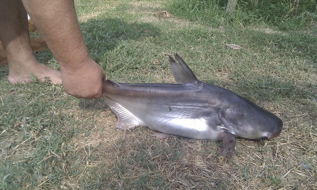
In my pharmacy kit I also have a box of anti-histamine and one of Diclofenac sodium, antibacterial eye drops, an eye shower, it's a half liter sterile plastic bottle of saline solution with an eye-rinsing-head on it (used it last month when a guy's potential dinner turned the tables by spitting a face full of venom on him, lucky it decided to head on without biting him first) and in my bag I have a 3 piece fishing rod (we had us some nice dinners on this last trip,
IMAG1000.jpg
including this one).
 
Luggage setups - 3 different long distance rider's that were here the other day


Honda XR 400 R


Several small bags attached with bungy's, he said he hadn't had any problems with them coming loose


FlickrDroid Upload by Triangle Golden 007, on Flickr


KTM 990 Adventure


Aluminium panniers and top bag. I personally think the disadvantages outweigh their advantages (aluminium panniers) in Asia. Son much of the time here you need to split traffic or get through small gaps and they will hinder your progress big time. A Giant Loop "n" shaped bag in the pillion riding position is much more efficient.


FlickrDroid Upload by Triangle Golden 007, on Flickr


Triumph 800 XC


Just loaded for an overnight ride here, 2 up (pillion), normal touring for them is with aluminium panniers


FlickrDroid Upload by Triangle Golden 007, on Flickr
 
.....Aluminium panniers and top bag. I personally think the disadvantages outweigh their advantages (aluminium panniers) in Asia. Son much of the time here you need to split traffic or get through small gaps and they will hinder your progress big time. A Giant Loop "n" shaped bag in the pillion riding position is much more efficient.

Phil I must agree with you. While Aluminum boxes offer great protection and ample space, and of course keep your belongings dry, they do take a considerable amount of space.
Also, while most remote travellers will tell you that they spend little time in traffic, truth is those water tight boxes add considerable buoyancy to your ride, exactly where you would want to be heavy and get as much traction as possible when doing a river crossing.

A buddy and I spent 2 hours rescuing a BMW R1200GS Adventure and her rider from the waters of the Riviere Rouge in Ontario. We had just crossed the river which was knee deep high with a little more current then we liked but all went well, then we stood there watching in disbelieve when the Beemer, who weights double our bikes, started lifting its ass and floating tail first into deeper waters. Lucky for the unfortunate my buddy actually had a rope with his few things he carried along and we were able to lasso the bike around the handlebar very quickly. Getting it out was a different story entirely though. Turns out he was training and his panniers were empty but of the fancy water tight Touratech kind.

The same thing really goes for gasoline and water cans. That is why with time I started using bags. They collapse when empty leaving you with little incombrance, no wobbling when fluids are being consumed, no buoyancy either. Also, bags will attract less thieves as they look poor (at least mine do LOL). Though I usually modify mine to have proper attachments rather than just bungy them...but elastics are good as they allow a level of flexibility...things move when hit hard, with alu panniers usually something brakes.

Personally, at first glance I would contend that the guy with the Honda has experience going by the way he's packed, despite the bungies.
 
this is the second time I write for hours and when I'm want to post I prompted to log in again...and of course everything's lost. CRAP! Don't feel like writing the exposee on navigation without gps again...maybe another day

don't go and get lost in the meantime :DD
 
Sorry to hear hours of work lost.

Maybe it's an idea to write long posts in word (or other format) and save the file, than copy/paste here and in case of a problem you still have the file.
Also works easier to cut and paste the links for the pictures in the word text.
 
Or I just make it short and simple...

Everyone knows how to read a map I'm sure...so don't leave home without one. When our gadgets give up we can take it out and by using a compass (shouldn't leave home without one either) we can measure any points of reference and trace them on the map. ideally 3 points, anywhere between 60 and 120 degrees apart. The resulting point (most likely a triangle) is your position.

No compass, put a stick in the ground, the point where the shadow is shortest points to North when looking from the base of the stick (in the northern hemisphere). Otherwise use these:
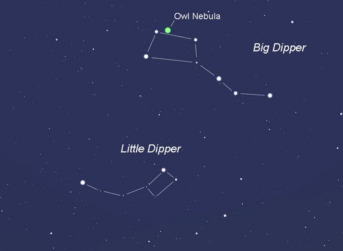
Owl_locator.jpg

Polaris is not always easily visible due to today's pollution, especially here where it is close to the horizon. The Big Dipper is mostly easily visible and recognizable, extending the 2 outermost stars five times the distance between them will give the position of Polaris, even if it is not clearly visible. Also, when horizontal the Big Dipper will lie directly over North.
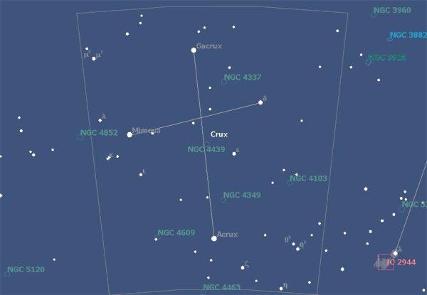
acrux.jpg

Another great reference, clearly visible in our location is of course the Southern Cross. Acrux, the star at the base is the closest to South...visually the Southern Cross rotates around the South Pole and the extension if the cross through Acrux will always show true South.
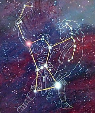
orion.JPG

When the aforementioned constellations are asleep then Orion will guide the way. Orion in itself is not easily recognizable, but...the 3 stars that make up the belt of the mighty hunter and the nebula of Orion that highlights the sword make for an arrow like figure. This "arrow" always points towards North, so positioning yourself parallel along the arrow will see you travelling north.

Now remember that stick in the ground?

If you are lost in the middle of Mongolia somewhere and really need to find your position to know which way to travel next then make sure the watch you never leave home without has GMT on it.

When the shadow from the stick is perfectly aligned South-North mark the point of the end of the shadow and mark the exact time.

Your Longitude is given by your GMT time (difference to noon) - 15 degrees for every hour (example if it is 15:35:30) you are at 45,35'30" East
Your Latitude is 90 degrees minus the angle from the tip of the shadow to the top of the stick...plus 1/4 degree for every day after fall equinox going into winter solstice (+23.5deg) or from summer solstice going to fall equinox and minus a 1/4 degree for every day from winter solstice to spring equinox or from spring equinox till summer solstice (-23.5deg).
In the south hemisphere of course deduct form 0 degrees and reverse minus and plus.


Sorry if I didn't go into the detail that much anymore...but this should already give you a very good idea and let get more info if you really need to. I hope, and strongly suggest, that everyone actually just try it out.
 
A good habit it higlight all.. Copy then press post.. If it fails you can paste it back..

A habit I still cant get into remembering..
 
I did that a couple times but then I always have to go back and edit all the spaces that get lost...bummer. I just gave the short version without giving any history backgrounds and detailed explanations, should help. Besides, some may like better as they are probably not really interested in Amerigo Vespucci and can figure out on their own why 15 degrees per hour and 90 minus the angle...

good idea LivinLOS...hope the short version's ok though
 
One thing I did forget in the short version...

If you truly find yourself out there somewhere with GPS and phone screwed beyond repair...not having a clue where you are, the moment when you realize you're truly lost can be a little unsettling. Do not do anything irrational...do not start running around trying to retrace your steps or worse. Calm down, collect yourself, have a deep breath and a drink. If its late, get ready and settle in for the night, somewhere when you can stargaze...


Use all the tricks at your fingertip to find your position and orient yourself...so you can confidently head to safety in the right direction.
 
Do not do anything irrational...do not start running around trying to retrace your steps or worse.

This comment reminds me of the need to remain hydrated.
Many of us have probably experienced what dehydration can do to our normal logical decision-making processes.
It can (and has been) fatal.
 
"No compass, put a stick in the ground, the point where the shadow is shortest points to North when looking from the base of the stick (in the northern hemisphere)."

Well, this would work - if you watched the stick all day to see where the shortest shadow falls. An quicker way is to mark the tip of the shadow twice, about 15 minutes apart. A line drawn from the first mark to the second mark will run west to east.
 
this is the second time I write for hours and when I'm want to post I prompted to log in again...and of course everything's lost. CRAP! Don't feel like writing the exposee on navigation without gps again...maybe another day

don't go and get lost in the meantime :DD

Check the box remember me in the log in area. That way each time you open RA you are logged in automatically.
 
"No compass, put a stick in the ground, the point where the shadow is shortest points to North when looking from the base of the stick (in the northern hemisphere)."

Well, this would work - if you watched the stick all day to see where the shortest shadow falls. An quicker way is to mark the tip of the shadow twice, about 15 minutes apart. A line drawn from the first mark to the second mark will run west to east.

The idea is of course to do it sometime around noon...preferably between 11:30 and 12:30 (not so hard if you have a watch, and if you don't just some common sense by looking at the shadow). :D

Sorry to burst your bubble BobS (I assume you never had to try your idea otherwise you got lucky to be posting) Your idea only works if your 15 minutes apart are timed close to noon. Otherwise your line is going to run south-west to north-east in the afternoon and south-east to north-west in the morning, the degree varying by how far from noon you did the deed! Edit: Around these latitudes of course ... apologies for not specifying before.

- - - Updated - - -

Check the box remember me in the log in area. That way each time you open RA you are logged in automatically.
Thnx Bob...but will it remember what I posted?
 
"Sorry to burst your bubble BobS (I assume you never had to try your idea otherwise you got lucky to be posting) Your idea only works if your 15 minutes apart are exactly timed 7 1/2 minutes before and after high noon. Otherwise your line is going to run south-west to north-east in the afternoon and south-east to north-west in the morning, the degree varying by how far from noon you did the deed"

Let's see - your method might give you a dead accurate North-South line - IF your stick is exactly vertical and you can judge the EXACT moment that the shadow is shortest. Then, so what? You are still drawing a line on the ground and sighting as best you can.

The method I described will work any time of day, and give you a reasonable accurate West-East line. Yes, it may be SLIGHTLY slanted as you describe, but still good enough for rough navigation.

Wrong dude...SOO WRONG when accuracy and finding a position are required...

I have been doing this for decades and actually already used mine in extreme cases where we really needed it...and it worked. One time we got lost and off track on the Tanzerouff and using a stick (does actually not have to be perfectly vertical for anyone to see where the shadow is shortest...just take a few minutes and go out in the sun to try it...then try what you have been saying...) we found our exact position on the map and headed straight to Bidon Cinq without hitch. Your method would have gotten us to Casablanca provided we would have had enough fuel (this was a joke btw)....

I had to delete the rest as bashing you was a case of mistaken identity...apologies
 
Sorry fella but I know who's advice I'd follow - Ray's the man! Check at 1:46...

 
It's a way to get a relatively quick and OK 'bush' bearing - and seems to be the typically suggested (stick and shadow) method... Yes, you're right about the time of day, etc. but, around midday (a while after dawn or before dusk) it doesn't look so bad - unless you are off in the higher latitudes.

Here's a good Sun Path Calculator which (if you twiddle about with it) shows you how the path of the sun changes over the day and year, at different latitudes: http://astro.unl.edu/naap/motion3/animations/sunmotions.swf

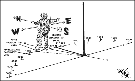
EDIT: Look further down on this page - good diagram and see how you can also use it to give you a rough idea of time: http://www.surplusandadventure.com/shop/home/product-information/navigation-equipment-methods.html

shadows.gif
 
Iv'e always found the best way is to ask the guy passing on the twenty year old step through with bald tyres and five kid's on board the way to the next village, works like a charm :LOL
 
.........shows you how the path of the sun changes over the day and year, at different latitudes:

Look further down on this page - good diagram and see how you can also use it to give you a rough idea of time

The suggestions of course are based on the fact that our gadgets are down so no internet access...but neat. And so is compass, similar to the one we were handed in the army...still have that one somewhere but I use a better one when out somewhere I might need it.

Nice info
 
Apart from the time difference between marking the end of the shadow points, was there any difference between the method Bobs described and the method in the video at 1:46???

And the other Bob method - there you go, thats proper navigation, something similar to my Burmese GPS mounted on the back of my WR when I got lost in Myanmar

6665690339_0fdb9aecbf_b.jpg
 
Apart from the time difference between marking the end of the shadow points.....

And the other Bob method - there you go, thats proper navigation, something similar to my Burmese GPS mounted on the back of my WR when I got lost in Myanmar


Sorry I should have gone more into detail again but was kind of fed up after writing for so long so I just did a quick rundown. Shit happens.

Love your Burmese GPS...looks like an accurate model (and comes with automatic bush clearing tool)...and Bob's method is quite good too, have been using it myself out in the Surin ricefields
:DD
 
Come on...

And your way might work with more accuracy only if you can check right at noon (solar noon - not going to be exactly 12:00 'clock' time that often)... And the closer you get to the equator the less accurate your method becomes as the stick will cast a shorter shadow to act as pointer... And you're going to have to follow the shadow far more carefully to spot the shortest point - with the other method, just 2x... And your method only works if you've got something straight to use - or the shadow won't be able to point well (and yes, it would have to be exactly vertical)... The W-E method could be drawn from the shadow cast by a feature of anything - e.g, by a fork in the branches of a crooked tree.

That info given on the other page I linked to is from the 'U.S. Army Map Reading and Land Navigation Handbook' - check page 9-6 here: U.S. Army Map Reading and Land Navigation Handbook - Department of the Army - Google ˹ѧÊ×Í

See how long it tells you to wait for... It's the time of day (relative to solar noon) you take the positions that's most important - not necessarily how long in-between. Eg, a few mins either side of solar noon would give you a truer W-E pointer than doing it for hours after dawn.

Practically, you can only mark and follow for/from either method in quite a rough fashion - hardly worth hanging around for long when there's perhaps more pressing concerns. Yes, if you know it's close to solar noon time and you've got something long and straight you can position at exact vertical to use, then fair play - your method might give you a slightly more accurate pointer - but otherwise...

EDIT: Google 'shadow stick compass' - see which method is typically recommended... If carried out reasonably correctly, this method is more accurate then your method, if both methods are carried out at the same time, at all times of the day, apart from at (or very close to) solar noon. The disadvantages of your method are that it would require more careful monitoring and something long and straight that can be fixed at exact vertical. Your method has no real advantage in how long it takes to carry out (the greatest accuracy is attained by both methods around the same time of day) unless you already know exactly at what time solar noon is - otherwise you would have to spend comparable total time monitoring for that, and likely use more time up actually monitoring.
 
Bikesncats - you might want to update your reading glasses. You are now writing that I put up posts about your milage claims. Do you just group together everyone who questions anything you say?

"BobS - Your imagination is as bad as your sight dude...I think you should stick around in the other forum where the i...s like Taliban Tony are...and maybe you want to take the time to correct your claim...if you read again -with your glasses on this time- you might see that I did 2,110Km in 15hrs and 46min (not 2,500 in 12 as you wrote, now that is impossible even on a racetrack)...you want to doubt it that's your prerogative, on the other hand you could bother reading a little more of this thread and see that I actually have posted a picture of my GPS to PROVE IT! "

Whatever anyone claims to have done means nothing to me unless it affects me in some way. So - keep writing your stories, true or not.
 
Whatever anyone claims to have done means nothing to me unless it affects me in some way...

Well...IF YOU ARE NOT the BobS that posted "...a guy in ride asia claims to have done 2500km in 12hrs here in Thailand..." in GTR...then I humbly apologize and ask you to forgive my hasty assumption. On the other hand, if you are, my post stands.


CRS...not sure what we're arguing about here...if you read my post accurately again...then you will see that I am actually saying to mark multiple points (not just one) that way one can see the shortest even if you missed high noon and draw your line, which you are going to need to calculate your position. In the end the methods are similar...but to have an accurate E-W line in the morning or afternoon you will require at least an hour apart, preferably 2.

And sorry I haven't looked at the manual yet...I still have my own somewhere (yes I was in the army and yes we were taught the same things) though I already knew most of it as I had been riding to remote areas for years already.

Now do me a favour and check what I wrote because...YOU WILL REQUIRE A NOON LINE IF YOU NEED TO FIND YOUR POSITION...your morning E-W line cannot help you calculate your position. Forgot to mention, if you do not have anything to measure the angle, use your watch, every second is 4 degrees you can reasonably measure within 1 degree.

Again, ideally we always have a working compass and we already have a perfect S-N line drawn from the base of the stick so we can mark the length of the line when it hits it, independently of what the watch sais, which could be far off in areas like China, Mongolia or the Sahara where a single time zone covers a vast area. Like it or not, no matter what other pressing matters we may have, when lost finding your position on the map is essential and for that, short of a sextant and an almanac, we need a proper watch, ideally know GMT (otherwise we need an additional line and the compass to calculate longitude) and knowing the date helps to add or subtract the sun's seasonal declination from equinox...and that line at high noon (yes solar...that's always implied)...

You can google as much as you like and find all the manuals possible...but until you're out there in a sea of sand or the steppe and try it for yourself it remains just that, another read.
 
Guys, please keep it civil - there is no need to flame each other - if you feel the need to do that please use the PM function as there is no need to involve the whole forum. And yes, Bob S and Jimbobs are two complete different people - Bob S lives up north while Jimbobs lives in Eesarn.
 
Well...IF YOU ARE NOT the BobS that posted "...a guy in ride asia claims to have done 2500km in 12hrs here in Thailand..." in GTR...then I humbly apologize and ask you to forgive my hasty assumption.


CRS...not sure what we're arguing about here...if you read my post accurately again...then you will see that I am actually saying to mark multiple points (not just one) that way one can see the shortest even if you missed high noon and draw your line, which you are going to need to calculate position. In the end the methods are similar...but to have an accurate E-W line in the morning or afternoon you will require at least an hour apart, preferably 2.

And sorry I haven't looked at the manual yet...I still have my own somewhere (yes I was in the army and yes we were taught the same things) though I already knew most of it as I had been riding to remote areas for years already.

Now do me a favour and check what I wrote because...YOU WILL REQUIRE A NOON LINE IF YOU NEED TO FIND YOUR POSITION...your morning E-W line cannot help you calculate your position. Forgot to mention, if you do not have anything to measure the angle, use your watch, every second is 4 degrees you can reasonably measure within 1 degree.

Nope - you'd better check what I wrote and read it more accurately.... I'm arguing (and explaining - with valid references) that the W-E method is better then your method.

In reply to your comments:

Yes, with your method you will have to mark multiple points = more monitoring = a disadvantage over the other method which just requires 2 points. Possibly, you might have other important things to be busy with...

With your method, if you miss solar noon then either the last or the first point you mark will be the shortest - depending on if you are checking before or after solar noon. Either way - at both (any) times either side of solar noon (unless very close), by design your method will be less accurate - do your geometry.

And, using the other (W-E) method, if you are checking morning or afternoon, leaving an hour or 2 between marking the 2 points doesn't help it to be more accurate - it's how close to solar noon you check that governs accuracy. The only way to improve the accuracy of a morning check is to wait and record the difference in time between then and solar noon then wait again and make another marker after that same amount of time has elapsed from solar noon - sometime in the afternoon. However, sitting around doing all this waiting might not always be the best idea - depending on your circumstances.

If you haven't read it, the manual says wait 10-15 minutes...
 
Nope - you'd better check what I wrote and read it more accurately.... I'm arguing (and explaining - with valid references) that the W-E method is better then your method.

......
And, using the other method, if you are checking morning or afternoon, if you leave an hour or 2 between marking the 2 points, that doesn't help it to be more accurate - it's how close to solar noon you check that governs accuracy. The only way to improve the accuracy of a morning check is to wait and record the difference in time between then and solar noon then wait again and make another marker after that same amount of time has elapsed from solar noon - sometime in the afternoon. However, sitting around doing all this waiting might not always be the best idea - depending on your circumstances.

If you haven't read it, the manual says wait 10-15 minutes...

The manual says 10 to 15 min when close to noon...

Are you for real???? You just repeated the same thing I said..."mark the points preferably between 11:30 and 12:30"...how in hell would you be able to miss the shortest point when you have at least 4 possibly 5 marks???? get real...again, show me how you calculate your position from the approximate E-W line you got in the morning...PLEASE enlighten us...

Ohh and I hate to tell you...using the E-W line in morning or afternoon - if you only need to find North (which usually comes with being lost but hey...) - marking 1 hour and 2 hours apart will give you a more accurate line if you draw it between the three points (2 extreme ends on one side, the middle on the opposite).

If you want to argue at least argue about a difference......I'm NOT interested in your E-W line dude...I'm interested in the exact angle of that (solar) noon shadow and the exact GMT time at which it was cast...that way I can position myself on the map within a few kilometer radius

Let me ask you...how many trips have you made into extremely remote places where finding and/or confirming your correct position (without GPS) on a daily basis meant the difference between going where planned or getting lost?
 
What? Repeating what you're saying? I think you are choosing not to recognise the points I'm making. I've explained enough, I think...

Can you not see the diagram (military looking guy with lines and stuff) posted above? Do you think the writers of the 'U.S. Army Map Reading and Land Navigation Handbook' are for real?

(Again, U.S. Army Map Reading and Land Navigation Handbook - Department of the Army - Google ˹ѧÊ×Í)

FIELD-EXPEDIENT METHODS

When a compass is not available, different techniques should be used to determine the four cardinal directions.
a. Shadow-Tip Method.
(1) This simple and accurate method of finding direction by the sun consists of four basic steps.
Step 1. Place a stick or branch into the ground at a level spot where a distinctive shadow will be cast. Mark the shadow tip with a stone, twig, or other means. This first shadow mark is always the west direction.
Step 2. Wait 10 to 15 minutes until the shadow tip moves a few inches. Mark the new position of the shadow tip in the same way as the first.
Step 3. Draw a straight line through the two marks to obtain an approximate east-west line.
Step 4. Standing with the first mark (west) to your left, the other directions are simple; north is to the front, east is to the right, and south is behind you.
(2) A line drawn perpendicular to the east-west line at any point is the approximate north-south line. If you are uncertain which direction is east and which is west, observe this simple rule--the first shadow-tip mark is always in the west direction, everywhere on earth.
(3) The shadow-tip method can also be used as a shadow clock to find the approximate time of day.
(a) To find the time of day, move the stick to the intersection of the east-west line and the north-south line, and set it vertically in the ground. The west part of the east-west line indicates 0600 hours, and the east part is 1800 hours, anywhere on earth, because the basic rule always applies.
(b) The north-south line now becomes the noon line. The shadow of the stick is an hour hand in the shadow clock, and with it you can estimate the time using the noon line and the 6 o'clock line as your guides. Depending on your location and the season, the shadow may move either clockwise or counterclockwise, but this does not alter your manner of reading the shadow clock.
(c) The shadow clock is not a timepiece in the ordinary sense. It makes every day 12 unequal hours long, and always reads 0600 hours at sunrise and 1800 hours at sunset. The shadow clock time is closest to conventional clock time at midday, but the spacing of the other hours compared to conventional time varies somewhat with the locality and the date. However, it does provide a satisfactory means of telling time in the absence of properly set watches.
(d) The shadow-tip system is not intended for use in polar regions, which the Department of Defense defines as being above 60° latitude in either hemisphere. Distressed persons in these areas are advised to stay in one place so that search/rescue teams may easily find them. The presence and location of all aircraft and ground parties in polar regions are reported to and checked regularly by governmental or other agencies, and any need for help becomes quickly known.

EDIT: You can download the complete handbook here: http://www.uvm.edu/~goldbar/FM3_25.26.pdf
 
Now, for those who don't have sticks, but do have a watch with hands (not digital), this trick works as well.

Hold the watch level, and point the hour hand at the Sun. Assuming a 12 hour dial on the watch, halfway between the hour hand and 12 will be South. If you had a 24 hour dial, 12 would be South.

Of course, this is rough navigation, and only works during daylight :-)

Sorry folks - just watched the video posted by CRS, and saw that I am repeating the info.
 
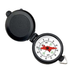
Interesting reading all this stuff with stick's and watches and the like and it's enjoyable and educational reading for sure, but why not just carry a cheap compass as a back up or am i thinking too laterally :excuseme:

41JIlpFuUWL._SY300_.jpg
 
I pull over to the side of the road, find something to drain my oil into, remove my magnetic sump plug, go hunting around a village for a nail, magnetise the nail, put the sump plug back in, re fill the oil & then hang the nail from a bit of string.
Now at least I know which way magnetic north is.
Works every time & is more accurate than the sun, although a bit messy at times.
 
What? Repeating what you're saying? I think you are choosing not to recognise the points I'm making. I've explained enough, I think...

Can you not see the diagram (military looking guy with lines and stuff) posted above? Do you think the writers of the 'U.S. Army Map Reading and Land Navigation Handbook' are for real?

(Again, U.S. Army Map Reading and Land Navigation Handbook - Department of the Army - Google ˹ѧÊ×Í)


EDIT: You can download the complete handbook here: http://www.uvm.edu/~goldbar/FM3_25.26.pdf

I take from your answer, not really answering but instead citing more manuals etc., that you actually never had to find your position anywhere...
BTW, thanks for the instructions but I don't need a military manual to know how to build a sundial...

Look I'm not interested in arguing this at nauseoum with you guys so let's just agree to disagree about the relative precision of each method.

While I know how to find my position with mine...let me ask you one last time clearly and simply...how do you find your current location with your method? ...please humor me...

Bob you are absolutely correct...but I use a slightly more complex compass that has a little ruler and allows to measure angles. That way when the string - with the stone attached to it that I use to make sure the stick is vertical - is placed from the tip of the shadow to the top of the stick I can measure the angle and calculate my latitude. As explained below...and accuracy is guaranteed by drawing a line south to north from the base of the stick so I can get the exact length (and angle) at noon and mark the time of this event, that way I also have my longitude.

When riding in remote areas where points of reference are few and far in between - without a GPS - this method applied daily will let you compare (and confirm) your position to the running fix and insure that you are on course to your destination.

Pounce...two thumbs up :jump
 
Guys, please keep it civil - there is no need to flame each other - if you feel the need to do that please use the PM function as there is no need to involve the whole forum. And yes, Bob S and Jimbobs are two complete different people - Bob S lives up north while Jimbobs lives in Eesarn.

Thank you for that...sorry I missed it earlier. BobS, please accept my apology for hastily assuming it was you and let me retract my bashing...
 
Back
Top Bottom