Unknown beauty SW of Mae Sariang

KTMphil

Senior member
Joined
Jan 11, 2011
Location
Chiang Mai, Thailand
Bikes
2007 KTM 990 Adventure Suzuki DRZ 400
Unknown beauty SW of Mae Sariang


I had been talking with Auke over a few beers about where might be an untouched area with trails, villages and borders. He said "I know just the area, go SW of Mae Sariang".

The next couple days we sat down together and with various data, identified what would be the best location.


Below gives you an idea of the breath taking beauty that was to be had.

6775621449_fcb9968d65_b.jpg


A quick afternoon drive down to Mae Sariang, stayed at the Kamolsorn Hotel, next to the main Police station in Mae Sariang.

6775675281_e18584d159_b.jpg


450 bht for aircon, free wifi & hot shower, decent value for the center of town

6775674565_20eae3f526_b.jpg


6775674211_2025831673_b.jpg


A stroll around the colorful evening food market

6775673577_de42e528d8_b.jpg


Being on the Salween river, fish is in abundance in Mae Sariang

6775674075_a039e77ec5_b.jpg
 
Sun goes down in Mae Sariang & off for some food.

6775673165_8ef9dffd31_b.jpg


If you want ok food with views go to the Riverside restaurant, if you want fantastic food go to Intira

6775672767_3e31ddc9d1_b.jpg


The owner even has a CB 1300 in excellent condition.

6775672331_3f1a26c9c4_b.jpg


Intira restaurant

6775671819_31f6caba38_b.jpg


6775671185_3220eb2edf_b.jpg


Great food

6775670565_fd56b4d5f5_b.jpg
 
The next morning -up at 0600am, freezing cold and off mapping SW of Mae Sariang

6775669191_af7c8659b7_b.jpg


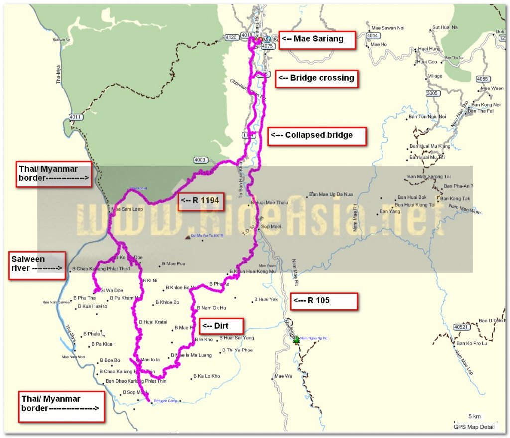
Not a good start the bridge to cross the Mae Yuam river has been washed away in the record rainy season floods, just this red can as a warning too.

6775668813_46a77d08ea_b.jpg


6775668333_9eac340eba_b.jpg


Found another bridge further north, then continued south to the unexplored Karen village area. We didnt really know what to expect in this area, from google earth it looked like mostly dirt tracks carving through mountains. An unexpected early morning mist cloud rising, hopefully will look better higher up.

6775667715_93ec7f712a_b.jpg


& it did, higher up looked fantastic

6775664165_e6bb4cb0b9_b.jpg


6775655163_7e592fd803_b.jpg


This Thai gentleman worked with a local NGO. spoke excellent English and gave me some pointers as to where fuel would be available

6775658707_38c4d1d49d_b.jpg


Views many have never seen before in this unexplored region

6775660117_542a4376ba_b.jpg
 
Around the next bend some more mist clouds, the rewards of early morning

6775656533_1ce302787d_b.jpg


Then off into the unknown, lots of Karen villages


SW of mae sariang.jpg
 
The main road through was concrete most of the way , all of the off-shoots were dry mud, it looked like a nightmare in rainy season

6775654029_d59da9cd8e_b.jpg


6775653095_c690c7dfe5_b.jpg


6775651823_05c8b993e4_b.jpg


Tradition style building at the end of one of the trails

6775652485_7788630fc7_b.jpg


Collecting the firewood in the hot sun

6775650747_fb9d3e66af_b.jpg


The first remote Karen village, look at how bad the road is from the soft mud and traffic

6775649313_416346c636_b.jpg


There was benzine available here, 50 bht a liter

6775647889_ac546a6247_b.jpg
 
This river was too deep to cross, so had to use the bridge, 3 hansom Karen boys posing for me

6775646711_5777c7e57e_b.jpg


Wasn't a problem

6775645997_2ce20f7049_b.jpg


Next village with a Thai military checkpoint

6775645287_247724f61f_b.jpg


Would be interesting to know the story behind this

6775644517_742dcfea61_b.jpg


The remote Karen villages were stunning with their leaved roofs.

6775644201_507e9480e5_b.jpg


6775642903_d428429f8c_b.jpg


Any power they had seemed to be solar generated

6775642153_e1546f7d63_b.jpg


6775641089_5f88c198d7_b.jpg


6775640283_d1c07ee7de_b.jpg
 
A bridge all ready for rainy season

6775639239_5acab0c94a_b.jpg


At the very southern end of my tracks the Nam Mae Yuam. A single track followed the river, something to explore at a later date

6775638657_d0a47531aa_b.jpg


A well ventilated school in the Karen village near the Nam Mae Yuam river

6775637357_073b5e8142_b.jpg


New construction

6775636773_99fdb34b86_b.jpg


Another great bridge

6775635561_17c4e4388c_b.jpg


Looks like it lead to some kind of home-stay or guest house


6775635023_5f68a5f429_b.jpg
 
Off to look for some more villages

6775634221_0c9810368c_b.jpg


Great river views from the mountain side tracks

6775632833_3d387d5fbe_b.jpg


Another Karen village

6775631815_70ee8fa350_b.jpg


6775630631_f6676f6b42_b.jpg


Again solar being the preferred choice

6775631245_f9f3aa77d9_b.jpg


Felt sorry for this monkey on a short chain

6775629873_554e091185_b.jpg


6775629385_ff7d1fbc4c_b.jpg


It didn't seem like they saw many visitors in these remote parts

6775629085_07bb14aabb_b.jpg


The fantastic views continued

6775625323_3021df2abe_b.jpg
 
This was the end of the road here, the digger was actually creating the road right then

6775624321_76da81771b_b.jpg


Off exploring, now the road was a slate rock covering, maybe had been blast by explosives


6775622289_bbac4215f8_b.jpg


I bet looks a little different in rainy season

6775618727_8fd56f0a40_b.jpg


The beautiful Salween river, here almost looks like the Mekong

6775616149_edc0f753c2_b.jpg


6775616859_eb31233c9a_b.jpg
 
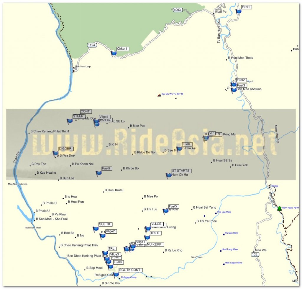
Managed to get a bunch of fuel shops waypointed as this is quite a large area, I'll see if I can get Auke to add them to the north Thailand dirt track & tarmac GPS map.

waypoints.jpg
 
KTMphil said:
Managed to get a bunch of fuel shops waypointed as this is quite a large area, I'll see if I can get Auke to add them to the north Thailand dirt track & tarmac GPS map.

Yes, will put them in once I am back from my work related visit to Vientiane. Great work and very nice additions to the map. Now, who is in for another trip quite a few have attempted but none seem to have made it through - the trip from Omkoi to the 105. There are quite a few pointers (taken from a military map) on the North Thailand Offroad GPS map on which roads to take. Please note that this is a very remote area with high ridges (about 1400 meter) and should only be attempted in the dry season according to the army guys I talked to when I was for work in that area.
 
You mentioned this one to me - I'm sure Max & Alex won't be able to resist the challenge - I'm up for it, I'm sure Luke will be too.


Lone Rider said:
KTMphil said:
Managed to get a bunch of fuel shops waypointed as this is quite a large area, I'll see if I can get Auke to add them to the north Thailand dirt track & tarmac GPS map.

Yes, will put them in once I am back from my work related visit to Vientiane. Great work and very nice additions to the map. Now, who is in for another trip quite a few have attempted but none seem to have made it through - the trip from Omkoi to the 105. There are quite a few pointers (taken from a military map) on the North Thailand Offroad GPS map on which roads to take. Please note that this is a very remote area with high ridges (about 1400 meter) and should only be attempted in the dry season according to the army guys I talked to when I was for work in that area.
 
Now your cooking!

Not sure why but i am having a word dump of those i haven't used for a while as people i know wouldn't understand them !

Phil those village and scenery pics are fabulous, well done.

:RO

Ally
 
Great stuff Phil, Im sure theres huge amounts left to explore out there still, cant wait to get involved in the next trip, shouldnt be long now... :DD
 
Great stuff Phil love the look of those roads,just the sort of ride i`m looking for.
 
Wonderful pix Phil, that is some great county you explored out there. Especially like the 1st shot of the Salween, seems even prettier than the Mekong to me...

Cheers, Mike
 
Back
Top Bottom