Captain_Slash
Community Manager
- Joined
- Jun 28, 2011
- Bikes
- BMW 310GS Honda Wave 125 Honda MSX 125
The Route 1090
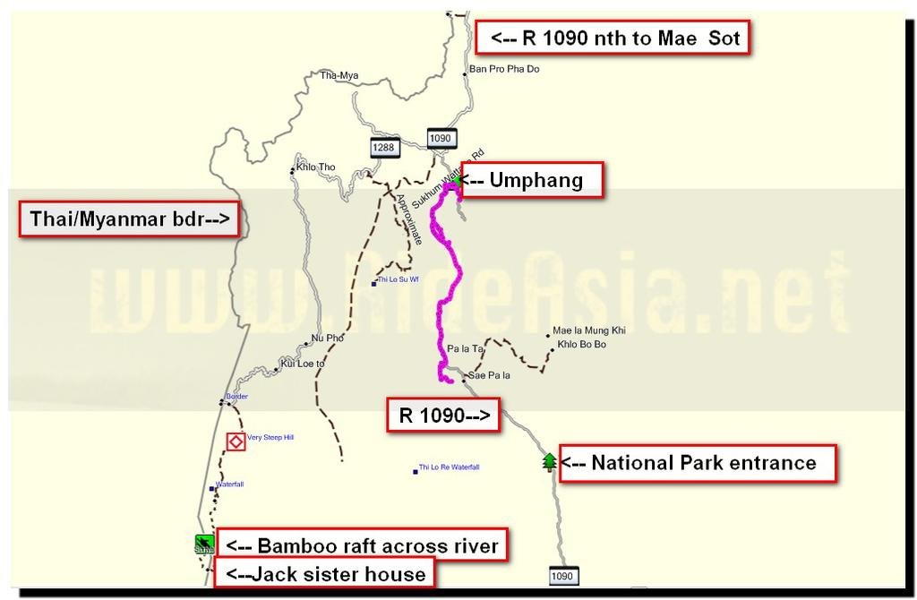
Total distance 81km on the KLX and 6-7 hiking

I get up for an early start then its starts chucking it down, just what I dont need today

It stops raining and I ride into town for breakfast and here it rains heavily again, I get some fruit and hang around for about 15 minutes and by then its nearly stopped and looking brighter in the distance

Todays destination

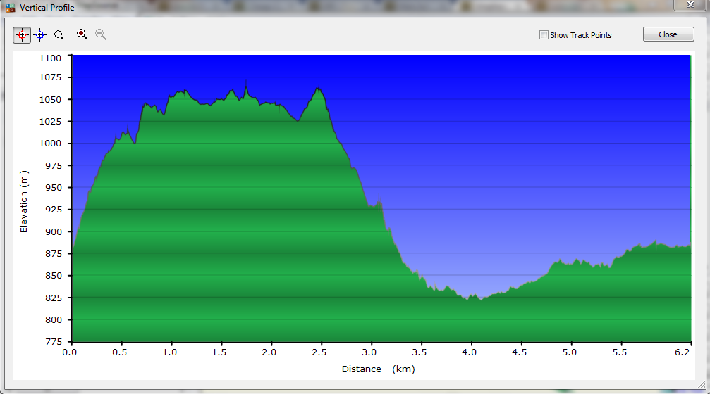
Heres the start of my hiking point at N15 57.725 E098 50.876, the GPS shows this as 887 m but I forgot to recoed the mileage here so have no accurate guage of how far I walked


Looking back down but at least I am doing it this year unlike last years holiday when I just wasnt in a good enough shape to even try it, that lost 17kg certainly has paid dividends


I note the mileage after I have climbed to 991 m and I walk another 5.9 km from this point


Its clouding in and I can hear thunder in the distance, oh well if it rains I get wet as theres no cover or shelter up here


Now for a really steep part to climb that needs the hands to help as well


The worst/hardest bit is now done and that I am glad about, for the last few climbs up here I have said this will be the last one but it never is and the plan on last years trip was to do it one last time with the GPS but that didnt happen

Care is needed in places as the fall wont do you any good plus theres no help up here

There are piles of stones in a few places but I have never seen anyone at this end of the hike in any of my climbs


1063 m was the highest I saw on the GPS which was a bit of a disappointment as the pounding in my chest and sweating had me thinking it was harder work than that


Sometimes the path disappeared and I just pushed on through the foilage, never having seen any rodents or anything that a snake would eat has led me to believe I will never encounter one up here so no worries there

It doesnt look so clever that way


The low level cloud is coming across now but its a blessing really as the temperature is lower than usual up here plus I am not bothered by insects today


I get the cameras timer working, thats good now I have proof I actually did the trip


Its raining now but not that unpleasant and here is a good spot for lunch


Its looking bleak whichever way I look now, visibility isnt great for the photos but I last walked up here when I was on the Phantom so that means I had my Sony digital camera on that trip so some sunny views will be seen by all

Lunch time, it looks like the sandwich I bought at the 7-11 in Mae Sot yesterday has got squashed, it still tasted nice though along with a fresh onion and fruit from the market


As I descend it brightens up and the rain stops


I finish the descent and get back to the road at N15 58.780 E098 50.202, the GPS tells me the KLX is 2.3 km from here, but thats as the crow flies


I see more cattle on the road then vehicles

Looking back up to where I was earlier on

Thats where I went but I didnt see the birds though


The KLX is still waiting for me

Exactly as I left it with the helmet chained to the rack and covered over with a pannier cover.
It was a 2.58 km walk back according to the GPS and it took me 25 minutes to walk.
Well I have now walked it with a GPS and today I said again this was the last time up there

Now off to visit the Palatha waterfall, the other thing I wanted to do today, time permitting

Sleeping on the job


I was a bit concerned the dirt track to the waterfall was going to be treacherous but it was okay, I am only riding in a t shirt and shorts today for obvious reasons


Through the woods and no problem with deep puddles or slimy clay today


There are a few turn offs along this track but after discovering it last year this time was simple as Auke has put this track onto the GPS map

The Palatha waterfall


My second time here and still only me here viewing it


Health and safety has arrived in Thailand


Time to walk back


I ride back to Palatha and go to the river but notice the farm vehicle crossing the bridge


He makes it and I ride down to the river

I on the other hand dont make it, that was not part of the plan

The KLX did not like that deep soft sand, sods law dictated that despite bringing a pair of football shin guards and always wearing them when on the bike that the only day I wasnt wearing them was the day I wished I was, not too much scrapped skin on the shins today though.
The beauty of FI, no petrol leaking all over the place, I just picked the bike up, put in in neutral, placed it on the sidestand, pressed the starter button and it just burst into life

A quick shot of the river then back home

A moo phad kapow at my usual eatery for 30 Baht

The fruit shop owner with her daughter

Those pineapples look nice, they are handing out slices as a taster and it was nice

A small one for 15 Baht was consumed
You can get the gdb file from my website here … http://www.captainslash.com
Total distance 81km on the KLX and 6-7 hiking

I get up for an early start then its starts chucking it down, just what I dont need today

It stops raining and I ride into town for breakfast and here it rains heavily again, I get some fruit and hang around for about 15 minutes and by then its nearly stopped and looking brighter in the distance

Todays destination

Heres the start of my hiking point at N15 57.725 E098 50.876, the GPS shows this as 887 m but I forgot to recoed the mileage here so have no accurate guage of how far I walked


Looking back down but at least I am doing it this year unlike last years holiday when I just wasnt in a good enough shape to even try it, that lost 17kg certainly has paid dividends


I note the mileage after I have climbed to 991 m and I walk another 5.9 km from this point


Its clouding in and I can hear thunder in the distance, oh well if it rains I get wet as theres no cover or shelter up here


Now for a really steep part to climb that needs the hands to help as well


The worst/hardest bit is now done and that I am glad about, for the last few climbs up here I have said this will be the last one but it never is and the plan on last years trip was to do it one last time with the GPS but that didnt happen

Care is needed in places as the fall wont do you any good plus theres no help up here

There are piles of stones in a few places but I have never seen anyone at this end of the hike in any of my climbs


1063 m was the highest I saw on the GPS which was a bit of a disappointment as the pounding in my chest and sweating had me thinking it was harder work than that


Sometimes the path disappeared and I just pushed on through the foilage, never having seen any rodents or anything that a snake would eat has led me to believe I will never encounter one up here so no worries there

It doesnt look so clever that way


The low level cloud is coming across now but its a blessing really as the temperature is lower than usual up here plus I am not bothered by insects today


I get the cameras timer working, thats good now I have proof I actually did the trip


Its raining now but not that unpleasant and here is a good spot for lunch


Its looking bleak whichever way I look now, visibility isnt great for the photos but I last walked up here when I was on the Phantom so that means I had my Sony digital camera on that trip so some sunny views will be seen by all

Lunch time, it looks like the sandwich I bought at the 7-11 in Mae Sot yesterday has got squashed, it still tasted nice though along with a fresh onion and fruit from the market


As I descend it brightens up and the rain stops


I finish the descent and get back to the road at N15 58.780 E098 50.202, the GPS tells me the KLX is 2.3 km from here, but thats as the crow flies


I see more cattle on the road then vehicles

Looking back up to where I was earlier on

Thats where I went but I didnt see the birds though


The KLX is still waiting for me

Exactly as I left it with the helmet chained to the rack and covered over with a pannier cover.
It was a 2.58 km walk back according to the GPS and it took me 25 minutes to walk.
Well I have now walked it with a GPS and today I said again this was the last time up there

Now off to visit the Palatha waterfall, the other thing I wanted to do today, time permitting

Sleeping on the job


I was a bit concerned the dirt track to the waterfall was going to be treacherous but it was okay, I am only riding in a t shirt and shorts today for obvious reasons


Through the woods and no problem with deep puddles or slimy clay today


There are a few turn offs along this track but after discovering it last year this time was simple as Auke has put this track onto the GPS map

The Palatha waterfall


My second time here and still only me here viewing it


Health and safety has arrived in Thailand


Time to walk back


I ride back to Palatha and go to the river but notice the farm vehicle crossing the bridge


He makes it and I ride down to the river

I on the other hand dont make it, that was not part of the plan

The KLX did not like that deep soft sand, sods law dictated that despite bringing a pair of football shin guards and always wearing them when on the bike that the only day I wasnt wearing them was the day I wished I was, not too much scrapped skin on the shins today though.
The beauty of FI, no petrol leaking all over the place, I just picked the bike up, put in in neutral, placed it on the sidestand, pressed the starter button and it just burst into life

A quick shot of the river then back home

A moo phad kapow at my usual eatery for 30 Baht

The fruit shop owner with her daughter

Those pineapples look nice, they are handing out slices as a taster and it was nice

A small one for 15 Baht was consumed
You can get the gdb file from my website here … http://www.captainslash.com


