Trails west of Chae Son; Lifan in the Jungle Part II

jb2112

Senior Member
Joined
Mar 17, 2012
Bikes
N/A
%257E1.jpg


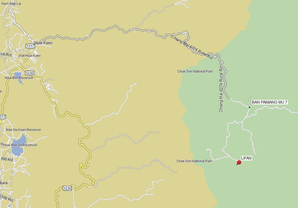
I rode a few new trails near Huai Kaeo then headed up the 4074 over the Lampang/CNX border. I found a few interesting trails on Google Earth and decided to see if I could ride all the way back to the 1230 (near Mae On) on dirt trails. It was an overcast, cool day riding over the mountain. As I neared my destination I looked back at this spot near one of the checkpoints. If you look carefully you can see that yummy trail in the distance. Unfortunately, the gate was down and I was alone, so I backed out. Google Earth shows that there is a nice road back there and there must be an awesome view from the peak to the SW. Gate located at 18.855668°, 99.367501°. There is also an unkempt dirt track on the north side of the 4074. I will check it out some other time.

P1020562.JPG


P1020563.JPG


P1020564.JPG


I walked up the trail just a bit and took this shot looking back at the road:

P1020565.JPG


The views were splendid today:

P1020566.JPG


P1020567.JPG


Here is my first waypoint: Ban Pamiang 18.828532° 99.387484°. I am looking for the dirt trail now to head S'ly and W'ly toward a trail that Phil and I rode last week.

P1020568.JPG


It turns into dirt a few hundred meters down the road. This bridge and adjacent water crossing is interesting now only because I have to go back with my truck. More later....

P1020569.JPG


Nice trail
P1020570.JPG


I decided to go left. If I had only gone right I think I would have found my connection.

P1020571.JPG


Another left
P1020572.JPG


P1020573.JPG


I made it through a village and up the mountain about 500 meters or so, then my clutch burned out....AGAIN!. Luckily, I coasted down back through the village and parked the bike here. The route up past the village is behind my bike and a shadowy right-hand turn at the storage shed.

P1020574.JPG


There were maybe 7 or 8 houses and only one had signs of life. It was a young Thai man and his infant son... in the bath. I apologized for walking up on them. He was happy to walk back and look at the bike. No one was around to give me a ride, so I left my gear at his house and left the bike where it was parked. I started walking back 5 or 6km to my starting point. Not fun in offroad boots. Luckily it was cool and there was only a brief rain shower. Also, I have been hiking (voluntarily!!!) so I was ready to do it.

I found some network access to make a call and luckily Fishenough was more than willing to come rescue me.

Here are photos from the walk:

P1020575.JPG


P1020576.JPG


Self portrait with forced smile

P1020578.JPG


Back to get the Lifan this week, get it fixed, AND SELL IT!!! I can't wait to get back here with a decent bike.
 
Well done JB; quite the Adventurer.
Any prizes for guessing what your next bike will be?
 
Thanks Ron.
Cheap and easy and new: The new CRF I am guessing.
;-)

I am re-posting your signature line here as it is certainly appropriate for me today:
A happy rider is one who can enjoy an unexpected detour along the way.
 
Correction - in JB's 2-wheel-drive pickup, they couldn't get to the bike, they've turned back.


KTMphil said:
Just spoke to JB in the jungle, I think he's got it in the pick-up already.


Fishenough said:
Mmmm, riding up the 4047 or working, which is better. :RO
 
Looks like we'll soon have a NOB ride in the area with all the new trails JB is discovering!

JB -> if you like exploring in rough areas, why not a proper adapted bike for those situations like a new modern 2 stroke?
 
Max,

Maybe, but all focus now is on getting this one retrieved, fixed up and SOLD right now. Thanks.

It was not a terribly difficult stretch but my Lifan gave up the fight.

That Chae Son park looks like a rider's playground!
 
KTMphil said:
Correction - in JB's 2-wheel-drive pickup, they couldn't get to the bike, they've turned back.


KTMphil said:
Just spoke to JB in the jungle, I think he's got it in the pick-up already.


Fishenough said:
Mmmm, riding up the 4047 or working, which is better. :RO

Yeah, my 2WD couldn't even make it up past the steep stretch just beyond Flight of the Gibbon.
I am presently getting some local help and I may have some helpful Thais on the Lampang side retrieve it and deliver it.

More to come as I am sure someone else may have some "fun" like this some day.
 
Lone Rider said:
Guess from the pictures and the waypoint, the Lifan is camping out here:

[attachment=0:366sdv25]Lifan Stuck.JPG[/attachment:366sdv25]

LR,
That looks about right.

In January Capt Slash made it through on the northern bit as shown in image below.
slash%2520overlay.jpg


He describes the concrete-stripped sections fairly accurately as pretty steep. This would be slow going for a 4WD vehicle. I did see a small pickup parked 3 meters from where I left the bike so it IS do-able.

http://rideasia.net/forum/captain-s...kunta-then-over-the-hills-off-road-t1381.html

Still waiting on word from that side of the mountain to see if it can be delivered from that end.
 
Lone Rider saves the day!

Lone Rider is one helluva great guy. After my Thai friends could not retrieve the bike with a 2WD pickup, Auke was more than happy to commit to picking me up here in Mae On on a dreary Saturday morning. I had never met the man before in my life and instantly I was at ease around him and his carefree attitude.

Instead of driving past Flight of the Gibbon we took the "short cut" up the 1230 near Huay Keao all the way up a village road past Ban Khun On. This is where Phil and I saw a group of Thai riders heading off down the Lampang side of the border. This is where I started the track on the GPS.
%257E2.jpg


Auke had his GPS and I think he was more prepared for this 4WD adventure than I was. Photos start below. A couple of the bridges made us edgy,but other than that it was just slow-going in 4WD and a nice day in the jungle. The red track that you see on the latest Google Earth screenshot is all double-track wide, but it is surely in very poor condition and will get worse in the rains. I think that you can judge how steep some of this track was from some of the photos below.

P1020591.JPG


P1020592.JPG


P1020593.JPG


P1020595.JPG


P1020596.JPG


P1020597.JPG


P1020599.JPG


Linking up with the track I had found 4 days ago!

P1020601.JPG


P1020602.JPG


STEEP!!!
P1020603.JPG


P1020604.JPG


I picked up my gear at the new friend's home and Auke and I loaded up the bike

P1020606.JPG


P1020607.JPG


And shots on the way out

P1020608.JPG


P1020609.JPG


So we now have a new gps track which does not line up with the googlemaps track at all. Good stuff!

Thanks Auke!
 
Here is (maybe) a slightly more dramatic screenshot looking E'ly. The last bit of trail is hidden behind the mountain but you can see the Lifan stickpin on the far right.
%257E3.jpg
 
Back
Top Bottom