Testing the new Nan map with Mark & Max / Alternative Nan Loop

KTMphil

Senior member
Joined
Jan 11, 2011
Location
Chiang Mai, Thailand
Bikes
2007 KTM 990 Adventure Suzuki DRZ 400
This was well worth it - Great views & everywhere still bright green, here looking out of the twisties on R 1216 south of Nan

8130595565_16f113db88_b.jpg


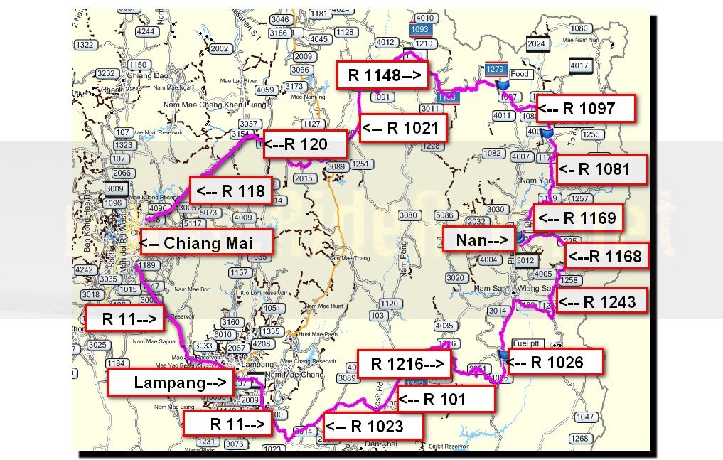
We took the infamous R 1148 eastwards from Chiang Mai to Nan, then using Lone Rider's last draft of the new Nan Road & Off-Road map, we looked for a creative loop back to Chiang Mai

2012-10-28_223321.jpg
 
Max had just got his new ER-6n after a 2 month wait & had never been to Nan before, so he was keen to join us.


8131232056_b3d21b93f7_b.jpg


It's hard not to take R 1148 to Nan, in fact I think I go that way every time

8131207275_13460a28ce_b.jpg


You can see why


8131206603_c095a9239b_b.jpg
 
With the seasons being changed now for about 3 weeks (no rain), you can just start to see the rice crop changing color from bright green to yellow


8131233360_fc024d9707_b.jpg


8131207817_f40d516a14_b.jpg
 
Gas stop for the 990cc beasts - interestingly, the blue on was averaging 14km/ per liter of 95 gasohol, the orange one 17-18km per liter, need to find out why so different, Mark thinks its the mapping


8131234954_4b15794ae5_b.jpg


We had plenty of time approaching Nan, so included R 1081 & R 1169 on the way south....2 great roads don't miss them

8131209369_9321411366_b.jpg


Views from R 1169

8131209925_bd16608de2_b.jpg


8131209757_268533ace6_b.jpg
 
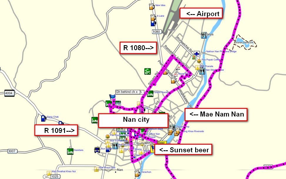
We tried a new GH which is behind Channel X night club in Nan, the "Ban suan pruk gh" co-ords:


N18.78556


E100.76706


8131236088_c4706b6315_b.jpg


350 bht with aircon, very convenient location, would stay there again

8131210109_3f315f5b32_b.jpg


Nan Radio 101 FM is on the grounds

8131210419_ca9887f648_b.jpg
 
Lone Rider wanted some final images for the Nan Road & Off-Road Printed Map, one of which was the Chao Fongkham House, this is on the grounds of Wat Phrakoed in Nan below


8131210597_903aab08b7_b.jpg


Wasn't obvious what the Chao Fongkham House was initially, but some locals helped us out

8131236534_2eb092f6a4_b.jpg


Looks like it's quite special, will find out some more about it

8131211665_2aed1cb8aa_b.jpg


8131237910_d8ab1859fe_b.jpg


8131238082_3d1de5e26e_b.jpg


This was pretty cool on the same grounds

8131238430_853436cd6f_b.jpg
 
Another one he wanted was "The King of Nan's House". We had the co-ords, but this was overgrown and hidden away, not obvious to start with


8130585925_04cd66cd62_b.jpg


We confirmed it was the right place & went in - what a gorgeous, old teak house, that King had style.

8130586037_77dc9f84b8_b.jpg


8130587171_25c20d655c_b.jpg


8130586455_7399c3b9ef_b.jpg


8130613630_098076dffb_b.jpg


The co-ords of the King of Nan's house are:

N18.77718

E100.77197


8130586311_98f50d4324_b.jpg


8130587469_a23c749f09_b.jpg
 
A sunset drink on the Nan river, this guy paddling down stream caught our eye

8130588681_0d1f90f83f_b.jpg


Looks like he lost his prop

8130588959_98694bfe9f_b.jpg


Off into the sunset

8130615122_31f675e9e2_b.jpg
 
Nan's pretty famous for its boat races, was interesting seeing the launch this 15 meter beast by hand while we were there


8130589479_4deed0330a_b.jpg


8130615724_97de1b517a_b.jpg


Good place to stop for a beer on the river is (co-ords):


N18.77468


E100.77791


sunset beer.jpg


8130614978_0eea5a9057_b.jpg


8130588115_1fd4fa01a1_b.jpg
 
Next day, we wanted to come a different way back to Chiang Mai from the fantastic R1091/ R 1251, so planned something a little different starting with the gorgeous, tree shaded R 1168, which runs east of Nan


8130616078_777887c3c1_b.jpg


8130590279_618e6ff44b_b.jpg
 
Then the windy R 1243, surface was pretty good considering rainy season just ended


8130616410_f57bb713a8_b.jpg


Beautiful morning views

8130590899_26baaf045f_b.jpg


8130616754_069613b251_b.jpg


It's a really fun road

8130591615_089bc2f556_b.jpg
 
So far, planning unusual routes with the prototype Nan map was great, it is very user friendly.

8130618318_227cb2df74_b.jpg


8130618458_4f3eb0a266_b.jpg


It caught one of the locals eye in Nan Noi & wanted to explore it

8130593395_bc29a7533d_b.jpg


He spent about ten minutes looking at it the said "Dee Mak" - thumbs up


8130618942_76f69dca07_b.jpg
 
There's a great local restaurant in Nan Noi (south of Nan) that Mr Rossi had stopped at a few times in the past, which does excellent food, co-ords are:

N18.32781

E100.71585


8130618622_3f76101469_b.jpg


Looks like you can find a room for the night there too now

8130618798_2985c2001b_b.jpg
 
We did some planning with the map prototype Nan map over lunch in Nan Noi, & wanted to explore (see "explore" on the map below) an un-numbered road which was just south of R 1026 on the clip/ screenshot of the map below


THIS IS WHAT THE NAN ROAD & OFF-ROAD PRINTED MAP WILL LOOK LIKE

8133292627_0c8a8c6677_b.jpg


As expected, there were some great views that none of us had seen before

8130619686_00d34250e4_b.jpg


Corn was about ready for harvesting

8130620020_8cf4ecc5dd_b.jpg


Then onto R 1216, a road with some of the most spectacular views in Thailand

8130594841_fe704b2471_b.jpg


8130621798_0fdaa01569_b.jpg


8130595221_5369738787_b.jpg


8130623054_92af055e18_b.jpg


8130621260_39b74f9ea9_b.jpg


8130595015_568aaea0df_b.jpg


Playing around with the focus

8130622120_e65f2ea3db_b.jpg


Highly recommend going there now while everywhere is still green

8130596695_21437d7b66_b.jpg


8130621928_69d830e345_b.jpg


8130622322_a82c25435e_b.jpg


8130622952_2a4617ae76_b.jpg
 
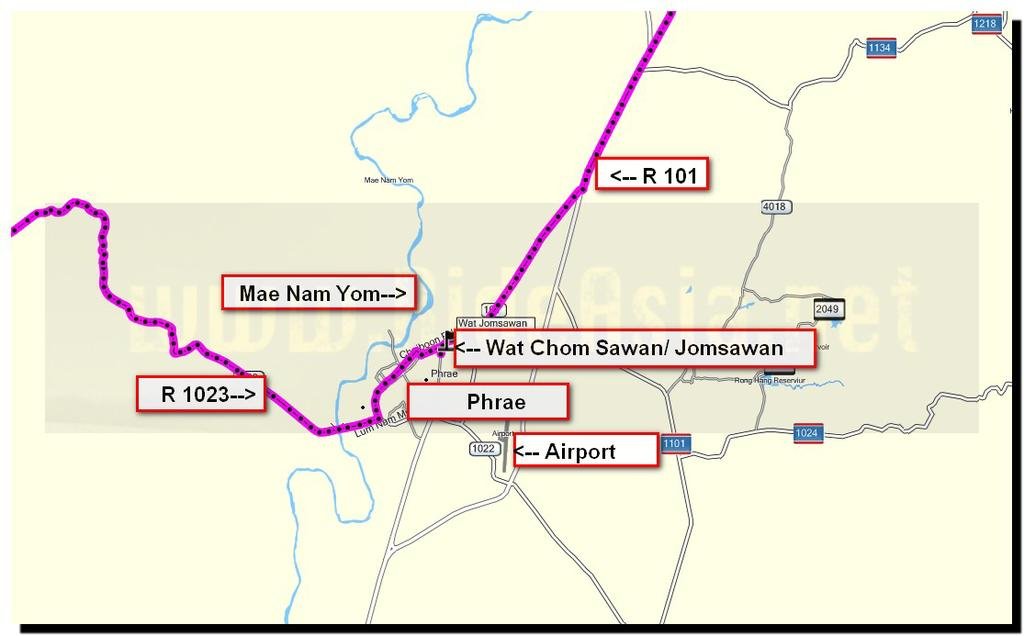
A quick drinkstop in Phrae & a look at Wat Chom Sawan (real name Jomsawan), co-ords:


N18.15092


E100.15072


It says this is the oldest Wat in Phrae, built in 1912

8130598055_5f47a6c209_b.jpg


Location in Phrae
wat chom sawan jomsawan.jpg


8130598335_8c05e9d95f_b.jpg


8130623472_b091f856af_b.jpg


8130624156_5e45bb2ebb_b.jpg


Quite breathtaking inside

8130624360_79b53b1e31_b.jpg


8130598887_a63f663e2a_b.jpg
 
Next to the Wat is the Jamsawan Monastery which was built in the King Rama V era

8130600239_6fb6d57b3b_b.jpg


8130625512_6ea5d5a055_b.jpg


8130625336_8c14e73559_b.jpg


From there, a blast up R 11 back to Chiang Mai - I think everyone will find the Nan Road & Off-Road printed map immensely useful, there's no other Nan province map that comes close.
 
Looking awesome along the 1216 going by those photos Phil, it looks like the Nan map is a definite winner too
 
nice route and bikes!

Quite nice northern Thai! So much like Yunnan. Gotta find a chance to ride your KTM990, Phil.
 
Oh crap. Here I sit in an airport hotel in Bangkok waiting for a three AM wake-up call to fly back to a snowy America and these photos just took me back over the last three weeks of riding bliss. A big thanks to everyone who posts up pics - esp Phil - that inspire an old fart to ride these roads. Time of my life! Keep 'em coming.

And the new Nan map was the cat's pajamas!
 
This thread seemed necro-worthy, hope you don't mind!

Any updates on roads in this area? Is the 1216 paved?? Can't quite tell from the pics...

I'm off to Mae Sai for a lil tourist visa out'n'in on cbr250r and was hoping to make it a loop via Nan.

 
Last edited:
Yep it's paved and the loop remains one of the best rides in the area.
 
Excellent! :D I'm liking how there's Streetview of all these roads, can quickly get an idea of pavement and scenery.

In avoiding the 101/11 might take 1024/1026 east out of Phrae and skip the 1217/1216 detour, will see how that goes... Gotta find a phone strap this morning or there will be a lot of map-squinting stops.

Planning to pop into CR for the Saturday night market, Bob?
 
Excellent! :D I'm liking how there's Streetview of all these roads, can quickly get an idea of pavement and scenery.

In avoiding the 101/11 might take 1024/1026 east out of Phrae and skip the 1217/1216 detour, will see how that goes... Gotta find a phone strap this morning or there will be a lot of map-squinting stops.


We did the 1024 from Phrae a couple of months ago.

Very slow going but really nice scenery.Probably averaged about 40k's/hr along it.

The ride along 1216 and through Khun Satan was well worth it IMO.
 
The ride along 1216 and through Khun Satan was well worth it IMO.

Thanks for that, stuck to the program and it was epic! Even caught a lil hilltribe new years bash at the top, rolled into Nan by moonlight... Whole trip was great, did ~1240km in 2.5 days along some amazing roads.


GBjq2C6.jpg
 
Excellent! :D I'm liking how there's Streetview of all these roads, can quickly get an idea of pavement and scenery.

In avoiding the 101/11 might take 1024/1026 east out of Phrae and skip the 1217/1216 detour, will see how that goes... Gotta find a phone strap this morning or there will be a lot of map-squinting stops.

Planning to pop into CR for the Saturday night market, Bob?


Sorry mate just seen your message I'm out on the road myself, so next time.

Sent from my SM-G900F using Forum Runner
 
Back
Top Bottom