Can anyone confirm that this route (hwy 2E) is now paved as it goes thru Phongsal Province via Muong Khua? I'll be returning from Northern Vietnam to Chiang Rai via this crossing and am worried about clay roads during the raining season. The lastest GT RIDER MAP (2012) shows it as a dirt road, but someone I met in Laos said it is now paved. HELP!!
You are using an out of date browser. It may not display this or other websites correctly.
You should upgrade or use an alternative browser.
You should upgrade or use an alternative browser.
Need Info on Udom Xai to Vietnam Border at Tay Trang
- Thread starter DJKNOX
- Start date
Lone Rider
Blokes Who Can
Road 2E is all paved - More info here (info from December 2012): Road 2E and 2W
Thanks so much Lone Rider... i'm looking forward to seeing Phongsali on a paved road!
Would you happen to know if the paving of the road from Nong Oy to Beng Phu Kham has been completed, allowing for a full Pakse - Paksong - Attapeu - Sekong - Salavan - Napong circuit? I believe based on your reports this is the last segment to be completed?
Would you happen to know if the paving of the road from Nong Oy to Beng Phu Kham has been completed, allowing for a full Pakse - Paksong - Attapeu - Sekong - Salavan - Napong circuit? I believe based on your reports this is the last segment to be completed?
Lone Rider
Blokes Who Can
Not sure if I understand your routing completely (in particular the part from Nong Oy to Beng Phu Kham which I don't find on the maps I have) but here is some information:
Pakse to Paksong is paved
There are a few ways to travel from Paksong to Attapeu:
1. Head north to Thateng (Rd. 16) and then turn east to Sekong (Rd 16) and then further south to Attapeu on Rd 1I - all paved
2. Head east from Paksong on Rd 16A to Munhouamuang (on Rd. 1I) to Attapeu - all paved
3. Head south from Paksong on Rd. 7815/9004 to Sanamxao on Rd 18A (all unpaved and not recommended in the rainy season) and then east to Attapeu (unpaved)
Attapeu to Sekong on Rd 1I - all paved
Sekong to Thateng, Beng (Bengoudom/Tangbeng) to Saravane (Rd. 16 and Rd. 1H) - all paved
Saravane to Napong (on Rd 13 South) via Rd 15 - all paved
In case you need more info, just ask
Thanks Lone Rider
I think it was your option 2 that I was looking at. Every map seems to use different names... so it's hard to communicate. Is the route that passes thru Ban Tom, Houay and Katam tok waterfall? Yes it joins route 11 halfway between Sekong and Attapeu.
A guesthouse said that part of that route was still mud... but someone else said that there is a new road being finished.
Lone Rider
Blokes Who Can
Thanks Lone Rider
I think it was your option 2 that I was looking at. Every map seems to use different names... so it's hard to communicate. Is the route that passes thru Ban Tom, Houay and Katam tok waterfall? Yes it joins route 11 halfway between Sekong and Attapeu.
A guesthouse said that part of that route was still mud... but someone else said that there is a new road being finished.
More info here: Road 16A in South Laos
Forest
Senior Member
- Joined
- Feb 28, 2014
- Bikes
- Vstrom650,CRF250 , Ducati 900ss ,Yamaha YZ250, Virago 400 etc..
sounds like u crossed into Vietnam with your own bike (?)where /how,more info please_?
cheers
cheers
Can anyone confirm that this route (hwy 2E) is now paved as it goes thru Phongsal Province via Muong Khua? I'll be returning from Northern Vietnam to Chiang Rai via this crossing and am worried about clay roads during the raining season. The lastest GT RIDER MAP (2012) shows it as a dirt road, but someone I met in Laos said it is now paved. HELP!!
Hi Forest -
Actually it's quite easy provided you have a virgin teenage daughter that you are willing to SACRIFICE to the GODs. I didn't have one and so had to procure one. The challenge was finding a teenage girl that was suitable in this day and age!
In all seriousness, I plan to post on the subject AFTER I have exited Vietnam... as I do not want to offer false details or hopes.
Suffice to say for now that it is taking some effort and the usual truckload of patience... and I'm not in the clear yet.
Lone Rider
Blokes Who Can
The first 23 km. or so from Lak Xao to the south, the road has been upgraded (March 2015) and parts with some re-grading might be ready for pavement (asphalt layer). This was always the worst part of the road in the rainy season as the road goes through the ricefields. From the junction which goes to the Nakai Nam Theun 2 Dam the next 7 km is still as it was before and nothing has been done yet but the road is covered with stones and gravel. From there the road is upgraded and paved all the way to Rd 12 at Gnommalath. More info and some pictures here: Rd 1E from Lak Xao to Gnommalath
Lone Rider
Blokes Who Can
Lone Rider - I would like to clarify our discussion about the road east out of Paksong... the new road is indeed completely paved. However, the road that takes one to the Katamtok waterfall is still very muddy this time of year.
Yes, you are right as they have made a new shortcut and part of the old road has been left untouched but the Katamtok falls can be reached along the paved road but quite a few of the other falls are on the unpaved and nor probably quite muddy road. Info here: Waterfalls in south Laos
Thanks so much. Looks like the rte south from Lak Xao to Tha Kheak might be doable if there's a pause for a day or two in the rain. I will check it out. My bike is not good in the clay... wrong tires.
What's your favourite ride in Laos?
Cheers
What's your favourite ride in Laos?
Cheers
Forest
Senior Member
- Joined
- Feb 28, 2014
- Bikes
- Vstrom650,CRF250 , Ducati 900ss ,Yamaha YZ250, Virago 400 etc..
thanx that'll be intersting to know which border u got in more then out,other riders did succeed in the past
Hi Forest -
Actually it's quite easy provided you have a virgin teenage daughter that you are willing to SACRIFICE to the GODs. I didn't have one and so had to procure one. The challenge was finding a teenage girl that was suitable in this day and age!
In all seriousness, I plan to post on the subject AFTER I have exited Vietnam... as I do not want to offer false details or hopes.
Suffice to say for now that it is taking some effort and the usual truckload of patience... and I'm not in the clear yet.
bsacbob
Administrator (Retired)
- Joined
- Jul 1, 2012
- Location
- Chiang Rai
- Bikes
- Honda CRM-AR 250, Honda CRF 250-L, Suzuki V Strom XT 650 Honda XR250 Baja BMW F650GS
This report from last year may give some idea of the road conditions.
http://www.rideasia.net/motorcycle-...ts/5494-lak-xao-who-knows-where-off-road.html
BTW what map are you using some of your place names are really funky to what most of us know ?
http://www.rideasia.net/motorcycle-...ts/5494-lak-xao-who-knows-where-off-road.html
BTW what map are you using some of your place names are really funky to what most of us know ?
Lone Rider
Blokes Who Can
Thanks so much. Looks like the rte south from Lak Xao to Tha Kheak might be doable if there's a pause for a day or two in the rain. I will check it out. My bike is not good in the clay... wrong tires.
What's your favourite ride in Laos?
Cheers
OK and hope that you will let us know how the road is now at the start of the rainy season. Most favourite road - wow, difficult question in particular as many roads have been upgraded from unpaved to paved but a few I like (by the way I use a truck and not a bike) are Rd 15 from Saravane to the Vietnam border (all paved) and Rd 11 from Xaybouly (north of Savannakhet at the end of Rd 9A) riding along the Mekong to Thakheak (all paved). One of the most boring roads is for me Rd 13 South from Thakheak to Savannakhet and then all the way to the border with Cambodia.
The 1E road from hwy 12 to 8 is fully paved except for the last 30 km leading into Lak Xao. However, most of the 30 km is more or less an all weather road, with only a few red clay patches. Absolutely no issue in the dry season. in the rainy season, I would suspect that these few patches would be problematic... but as they are not long sections, they are likely manageable given a little time and patience with a road bike. That 30 km stretch also passes thru about 4 villiages where bike repairs are possible.
Lone Rider
Blokes Who Can
The 1E road from hwy 12 to 8 is fully paved except for the last 30 km leading into Lak Xao. However, most of the 30 km is more or less an all weather road, with only a few red clay patches. Absolutely no issue in the dry season. in the rainy season, I would suspect that these few patches would be problematic... but as they are not long sections, they are likely manageable given a little time and patience with a road bike. That 30 km stretch also passes thru about 4 villiages where bike repairs are possible.
OK, thanks for the update
Bob I use the GT RIDER map, 2012 edition, along with Google Maps... both of which I find very disappointing... road numbers and village names all seem to vary. I also have a PERIPLUS map... but it doesn't even distinguish between major paved and minor dirt roads. Not sure what the purpose is of publishing such unhelpful maps....
bsacbob
Administrator (Retired)
- Joined
- Jul 1, 2012
- Location
- Chiang Rai
- Bikes
- Honda CRM-AR 250, Honda CRF 250-L, Suzuki V Strom XT 650 Honda XR250 Baja BMW F650GS
Oh that would explain it  bit late to mention now your on your trip but Gecko produce and excellent Laos paper map and on the GPS side of things you can't go far wrong with either Auke's or Don's GPS map's both of which have good detail and POI's
 bit late to mention now your on your trip but Gecko produce and excellent Laos paper map and on the GPS side of things you can't go far wrong with either Auke's or Don's GPS map's both of which have good detail and POI's
bsacbob
Administrator (Retired)
- Joined
- Jul 1, 2012
- Location
- Chiang Rai
- Bikes
- Honda CRM-AR 250, Honda CRF 250-L, Suzuki V Strom XT 650 Honda XR250 Baja BMW F650GS
Again not that it helps but Phil at riders corner in Chiang Mai stocks them. If your heading to Luang Prabang maybe charly at Laos off road adventures may have some. As you have already discovered the gt rider map is lacking somewhat.
Sent from my SM-G900F using Tapatalk
Sent from my SM-G900F using Tapatalk
Lone Rider: I will be exiting Vietnam in a couple of days... will provide a Vietnam report thereafter. I plan to go from Dien Bien Phu to Udom Xai, then from Udom Xai take hwys 13 and 3 to the Chiang Rai border. Your previous report confirmed all is good fron the Vietnam border to Udom Xai... but how about hwy 13 & 3? Its raining like mad now and need to avoid dirt or heavily broken roads. You've probably posted on this route... but cannot locate the report  .
.
 .
.bsacbob
Administrator (Retired)
- Joined
- Jul 1, 2012
- Location
- Chiang Rai
- Bikes
- Honda CRM-AR 250, Honda CRF 250-L, Suzuki V Strom XT 650 Honda XR250 Baja BMW F650GS
Route 13N and then route 3 is a beautifully paved road, but watch out for hydroplaning on the steep hills if it's raining very hard, route 2 from Khua is also paved but watch out for some pot hole sections.
Lone Rider
Blokes Who Can
Lone Rider: I will be exiting Vietnam in a couple of days... will provide a Vietnam report thereafter. I plan to go from Dien Bien Phu to Udom Xai, then from Udom Xai take hwys 13 and 3 to the Chiang Rai border. Your previous report confirmed all is good fron the Vietnam border to Udom Xai... but how about hwy 13 & 3? Its raining like mad now and need to avoid dirt or heavily broken roads. You've probably posted on this route... but cannot locate the report.
As far as I know everything is OK with both Rd 13 and Rd. 3 with both roads in very good condition. However, Rd 13 from Oudomxai to Nateuy (the junction to Boten/Chinese border and Luang Namtha) goes through the mountains and with heavy rains you might have some landslides and some localized flooding. The same is valid for the road (Rd. 2W) from the Vietnam border to Mueang Khoua and on to Oudomxay where you might have localized landslides.
Latest news from Rd 13 (Oudomxay to Nateuy) is that today there were some flash-floods near Nalae (about half way) but not sure if this is on Rd 13 or on other roads leading to Nalae. This is a picture from a bridge near Nalae from Facebook which was posted a few hours ago.

On the pictures it looks quite bad at the moment but much depends on how much rain is falling in the coming hours and days. I do know that more to the south (Xaysomboun, Paksan, Vang Vieng, etc.) there are also floods so I would advise to take it easy and if it looks bad to wait out things along the way.
One very good online source for travel books and paper maps is standfords.co.uk.
They stock a.o. the Gecko Map of Laos, 1:750.000 http://www.stanfords.co.uk/Home/Product-Detail/Laos_9783906593296.htm
They stock a.o. the Gecko Map of Laos, 1:750.000 http://www.stanfords.co.uk/Home/Product-Detail/Laos_9783906593296.htm
Thanks guys so much!!!
I just went from Cat Ba to Sapa along the Chinese border.... 10 days of heavy rain while dodging landslides, potholes, frantic chicken and buses. It would be great if the rain eases off for a while... but l'm expecting much the same in Laos. It couldn't get any worse... could it? Lol. Arriving home to BKK is looking but like a distant dream to me right now
Tomorrow I tackle Fanispan enroute to Dien Bien Phu.
I think ive nevet seen it rain like this before... just my luck!
I just went from Cat Ba to Sapa along the Chinese border.... 10 days of heavy rain while dodging landslides, potholes, frantic chicken and buses. It would be great if the rain eases off for a while... but l'm expecting much the same in Laos. It couldn't get any worse... could it? Lol. Arriving home to BKK is looking but like a distant dream to me right now

Tomorrow I tackle Fanispan enroute to Dien Bien Phu.
I think ive nevet seen it rain like this before... just my luck!
prince666
Senior Member
- Joined
- Jul 3, 2013
- Location
- Shandong (China)
- Bikes
- CF 250 Jetlux. CFmoto 650 MT Honda CRF 1000 DCT Yamaha 125 YBR KG
Route 13N and then route 3 is a beautifully paved road, but watch out for hydroplaning on the steep hills if it's raining very hard, route 2 from Khua is also paved but watch out for some pot hole sections.
The R3 is not s good as it was 2 years ago over the last 2 years I have been riding the R3 coming from China Bob it is slowly getting worse and worse due to mainly overloaded Chinese lorry causing big rips in the road caution should be posted about this road please.
But would like to say a few point about the AH3 , 2 years ago when I first rode this road it was a great road , but due to the overloaded Chinese trucks and badly constructed road IMO it's no joy to ride no more ,Deep ruts oil/ diesel spillage contributes to IMO a caution road to ride on
Caution posted in RR link ......http://www.rideasia.net/motorcycle-forum/showthread.php?t=7121&page=2&p=53037#post53037
Thanks Prince. I only need to go 80 km to the 3 intersection. Is it really bad or can one make reasonable progress... ie like 80 km in 2 hrs?
Bob I've only ever experienced hydroplaning in a car... so am not quite sure what specifically causes it on a bike? I assume you have to be going a pretty good speed... or can it happen at lower speeds? Any further advice on that as all the roads i'm on are heavy with rain these days....
Bob I've only ever experienced hydroplaning in a car... so am not quite sure what specifically causes it on a bike? I assume you have to be going a pretty good speed... or can it happen at lower speeds? Any further advice on that as all the roads i'm on are heavy with rain these days....
prince666
Senior Member
- Joined
- Jul 3, 2013
- Location
- Shandong (China)
- Bikes
- CF 250 Jetlux. CFmoto 650 MT Honda CRF 1000 DCT Yamaha 125 YBR KG
The first part of the road leaving Thailand is ok, its the middle section between Thailand and China which is bad so not sure what way you are going?
Just read 1 rider on Phil big ride to Russian has just came off on this road you are correct it dont matter how bad the roads are its all down to how fast you go ????
Just read 1 rider on Phil big ride to Russian has just came off on this road you are correct it dont matter how bad the roads are its all down to how fast you go ????
Udom Xai to Nateuy... apparently this is a mountain pass. I'm on a cruiser style road bike with sealed road tires... so roads with a lot of sections with long broken surface replaced with clay mud and gravel can be a problem for me... especially in heavy rain. But a road where one only has to weave around bad sections (without stops) while moving at 20 to 40 km/hr is just fine.
I just came off a 120km road a couple of days ago where the locals said "it was ok" Well ok meant a paved road that is completely broken for 75% of it's length, where one has to stop and almost walk the bike thru gigantic potholes full of water and mud. Then every 10km or so comes a section covered with mud landslide that is churned into deep clay soup by trucks and buses. These require one to push thru clay soup while your tires slip left and ride. What could have been a 2 hr ride became 6 hrs... and how I managed not to puncture a tyre on all the sharp rocks is beyond me.
So i'm kinda looking to discern between perfect unbroken paved roads and roads where it really is very difficult to pass without a dirt bike. If you recall that section of hwy 13, let me know how bad the surface has become.
As for your comment about China being a NO LOGIC ZONE, I have to chuckle. I lived in China for 5 years... let's just say they have a unique way of problem solving!
prince666
Senior Member
- Joined
- Jul 3, 2013
- Location
- Shandong (China)
- Bikes
- CF 250 Jetlux. CFmoto 650 MT Honda CRF 1000 DCT Yamaha 125 YBR KG
With 5 years riding in China you will be just fine, the R3 is not as bad as
Just section you need caution???
Have a great trip and ride safe
road that is completely broken for 75% of it's length, where one has to stop and almost walk the bike thru gigantic potholes full of water and mud. Then every 10km or so comes a section covered with mud landslide that is churned into deep clay soup by trucks and buses. These require one to push thru clay soup while your tires slip left and ride. What could have been a 2 hr ride became 6 hrs... and how I managed not to puncture a tyre on all the sharp rocks is beyond me.
Just section you need caution???
Have a great trip and ride safe
Lone Rider
Blokes Who Can
The roads from Oudomxay to Nateuy and onwards to Luang Namtha and Houayxay are generally (for Laos) in very good condition but of-course there are short sections which are less good (overloaded trucks which damage the road surface, diesel spills, etc.) but these things are very common in Laos. At the moment you will have to be careful as with all the rains at the moment there no doubt will be sections with mud on the road from landslides, runoff (water, mud and gravel, etc.) and the road surface can be very slippery as a result.
The Oudomxay to Nateuy road goes through the mountains and is a 2-lane road with lots of freight traffic to and from China so you have to be careful as the big trucks often need/take more space in the corners and bends leaving little space for bikes.
The Oudomxay to Nateuy road goes through the mountains and is a 2-lane road with lots of freight traffic to and from China so you have to be careful as the big trucks often need/take more space in the corners and bends leaving little space for bikes.
bsacbob
Administrator (Retired)
- Joined
- Jul 1, 2012
- Location
- Chiang Rai
- Bikes
- Honda CRM-AR 250, Honda CRF 250-L, Suzuki V Strom XT 650 Honda XR250 Baja BMW F650GS
The R3 is not s good as it was 2 years ago over the last 2 years I have been riding the R3 coming from China Bob it is slowly getting worse and worse due to mainly overloaded Chinese lorry causing big rips in the road caution should be posted about this road please.
Caution posted in RR link ......http://www.rideasia.net/motorcycle-forum/showthread.php?t=7121&page=2&p=53037#post53037
If i recall the OP was coming from Dien Bien Phu not China, i rode this route from Khoua to HX in mid April in torrential rains as i said it is beautifully paved compared to how it was several years ago, but as others have already said the overloaded trucks tend to carve hollows in the corners. Like all roads ride to the conditions in front of you, route 3 has some very steep mountain sections, in very heavy rain and it like riding up and down stream where traction is limited.
Dont see any need to announce a road caution for this road, it is still way better than many others in Laos.
prince666
Senior Member
- Joined
- Jul 3, 2013
- Location
- Shandong (China)
- Bikes
- CF 250 Jetlux. CFmoto 650 MT Honda CRF 1000 DCT Yamaha 125 YBR KG
For people who do a lot of dirt/off-road riding like you then R3 is a good road on the right bike, for people who are just passing through Laos to Thailand or the other way then it could catch you out.
Like it did with Don
So I think the caution has already been made Bob IMO
Like it did with Don
We stopped to wait for 5 bikes that had disappeared behind, they were too long, we knew something was up. R3 had some really bad uneven sections from the heavy trucks. Don had hit one of these and came off
So I think the caution has already been made Bob IMO
bsacbob
Administrator (Retired)
- Joined
- Jul 1, 2012
- Location
- Chiang Rai
- Bikes
- Honda CRM-AR 250, Honda CRF 250-L, Suzuki V Strom XT 650 Honda XR250 Baja BMW F650GS
Ok Steve just for you..
CAUTION

Route 3 From Huay Xai to the 13N junction to Boten and Oudom Xai is an extremely dangerous road and should be travelled with extreme care, it is littered with nasty things such as bends in the road Tarmac and mountains and should be avoided at all costs.

CAUTION

Route 3 From Huay Xai to the 13N junction to Boten and Oudom Xai is an extremely dangerous road and should be travelled with extreme care, it is littered with nasty things such as bends in the road Tarmac and mountains and should be avoided at all costs.
prince666
Senior Member
- Joined
- Jul 3, 2013
- Location
- Shandong (China)
- Bikes
- CF 250 Jetlux. CFmoto 650 MT Honda CRF 1000 DCT Yamaha 125 YBR KG
[FONT="]Now Now Bob not quite what I had in mind but will do Thanks ..............[/FONT]
Lone Rider
Blokes Who Can
DJKNOX - Road 2E from the Vietnam Border to Oudomxai is causing problems at the moment due to landslides and lots of mud on the road

Landslides cleared along Rd. 1B but the roads are still very muddy
More info here: http://www.rideasia.net/motorcycle-forum/showthread.php?t=7317&p=54489#post54489

Landslides cleared along Rd. 1B but the roads are still very muddy
More info here: http://www.rideasia.net/motorcycle-forum/showthread.php?t=7317&p=54489#post54489
Damn that looks bad  Oh well I have no choice. But that is a picture of 1B... hopefully 2E is not THAT BAD.
This may be a naïve observation, but I really wonder how Laos and Vietnam can build brand new roads and not take provisions to minimize land slide damage. The raining season is an ANNUAL affair!
I'll give some updates shortly. I will be approaching the border tomorrow morning.
 Oh well I have no choice. But that is a picture of 1B... hopefully 2E is not THAT BAD.
This may be a naïve observation, but I really wonder how Laos and Vietnam can build brand new roads and not take provisions to minimize land slide damage. The raining season is an ANNUAL affair!
I'll give some updates shortly. I will be approaching the border tomorrow morning.
prince666
Senior Member
- Joined
- Jul 3, 2013
- Location
- Shandong (China)
- Bikes
- CF 250 Jetlux. CFmoto 650 MT Honda CRF 1000 DCT Yamaha 125 YBR KG
Hi Djknox
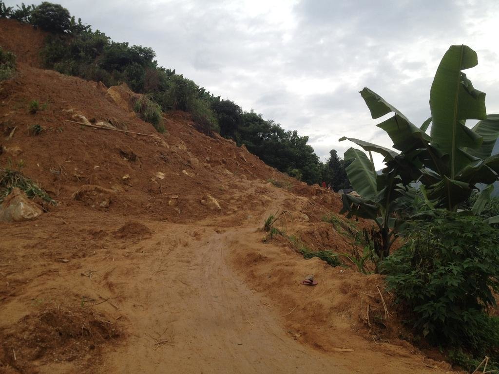
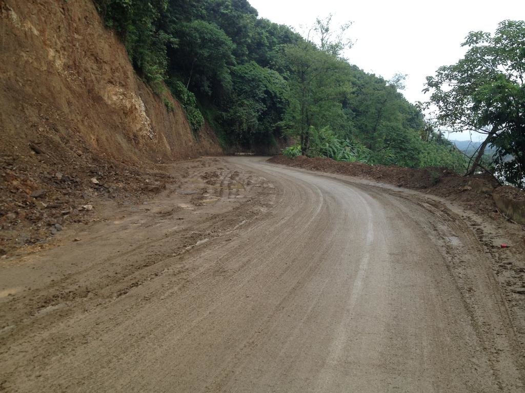
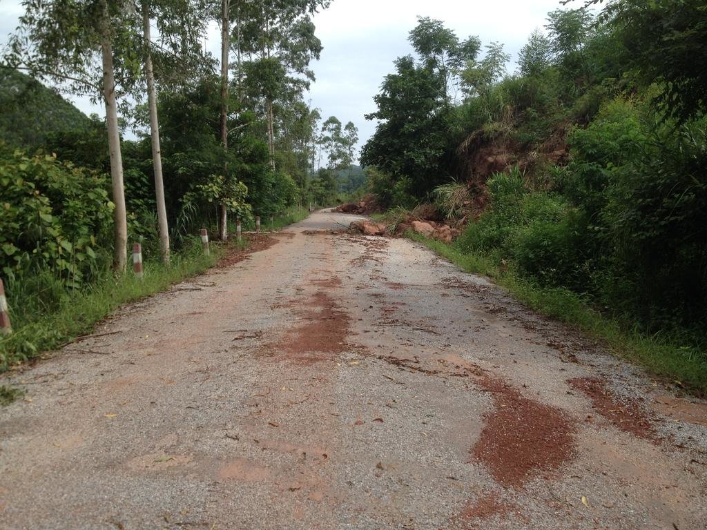
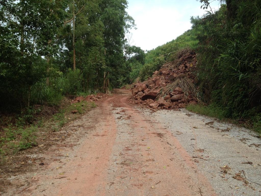
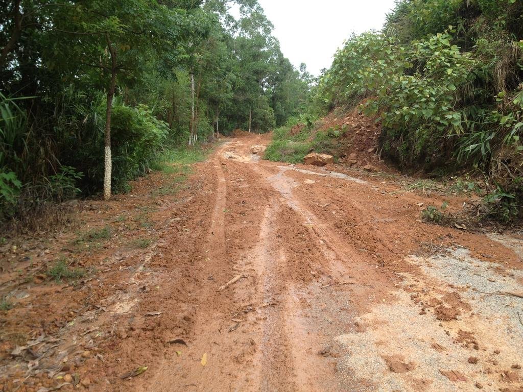
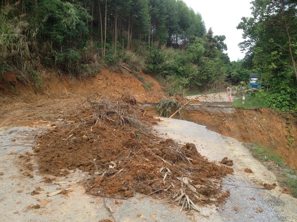
I don't thing its only Laos and Vietnam that's has this problem here are a few pictures from China with some landslides .
And I think because the nature of the roads cutting away whole side of mountains would not be cost effective IMO
The fist picture is of a landslide jus happen maybe 2 days ago the rest are of landsides which has been cleared or partly cleared


| Thread starter | Similar threads | Forum | Replies | Date |
|---|---|---|---|---|
|
|
Phonsavan To Vieng Xai In Need Of A Curry | Laos Ride Reports | 4 | |
| M | Latest information on Long Tieng? | Laos Ride Reports | 5 | |
| H | Latest Crossing Needs? | Laos Ride Reports | 13 | |
| M | Need a Road Report for Paksan to Phonsavan | Laos Ride Reports | 2 |

