More trail pioneering in the Omkoi region

KTMphil

Senior member
Joined
Jan 11, 2011
Location
Chiang Mai, Thailand
Bikes
2007 KTM 990 Adventure Suzuki DRZ 400
Lots of 2-stroke oil packed, who knows where this will take us


10682257493_8249de0b0b_b.jpg


LR has kindly converted the second set of David Bailey's google earth tracks to Garmin format, David says it was over 60 hours of work putting them together, so this should be a cool adventure into the unknown.


3 bikes & 4 of us going, more to come in a few days


10682408254_37908ac562_b.jpg
 
Don't do it all Phil, Bob & I want something new to find when we're there.
 
Arriving in Omkoi with no drama's, Mr Bailey goes through his Google Earth tracks with the owner of the Omkoi Resort, he's quite taken back at the detail we have!


10706265583_aa4fcdb30b_b.jpg


Mai's smile says it all about how this trip went

10769138566_dcb63387de_b.jpg
 
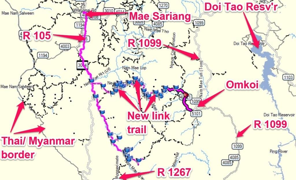
The map below shows the new trail data we captured, a big thankyou to David Bailey for spending days and days going through Google Earth, this saved an immense amount of time.


map txt.jpg


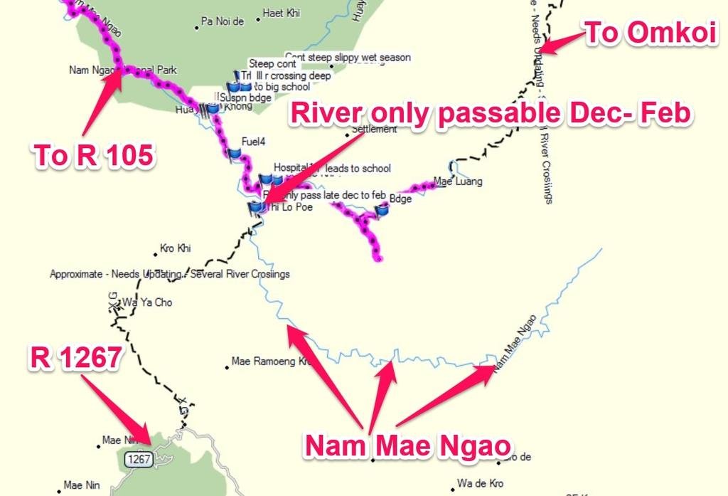
We finally figured out what happens at the northern end of R 1267 at the river. It is link-able through to the Omkoi trails, but only cross-able from 2nd half of December to the end of February. Bikes still need to be carried across then, there is no bridge.


R 1267 map txt.jpg
 
:hmm"but only cross-able from 2nd half of December" That's handy to know Mr Pounce ......

Well done guy's, and gal's
 
They'd had some heavy rains from depressions since the last time we were here with Bob, so it was interesting to see how rutted everything would be, below is about 15km west of Omkoi


10770695606_a161b809ae_b.jpg


As you get further west, there's some great road signs of the hundreds of Karen villages in the area


10770746434_9c8944667c_b.jpg


A clear day with decent viz, it wasn't too long before you wanted to slow down and just take in the surroundings


10770738494_9d1a7dfdac_b.jpg


10770636565_413ba17f45_b.jpg


Mai & David two-up off ahead in the distance


10770902093_340be07035_b.jpg


Most of the terrain here is quite sandy, with light rain it will just run through and not affect riding conditions


10770623255_e0ebecb811_b.jpg
 
Phil you always manage to show up the difference between a camera and a good camera, probably the operator has a lot to do with it. Great photos.
 
Off westwards we go into a region that's totally un-documented. All we have is an estimate from satellite images that there's possibly a way through.


Nearly all of the villages had Honda Wave's and fuel was available everywhere, the most we paid was 80 Bht a liter!


10770887213_f79b5973ea_b.jpg
 
Sipsonpanna style of terraced mountain rice


10770879803_d70b98f3d5_b.jpg


Trails were going off in all directions, we rode along most of them and the ones we didn't get to the end of, we marked as continued and will complete in the near future. I love this region!


10770874983_2b90fdec95_b.jpg
 
With the weather drying out it was harvest time all around us, the different colors in the fields from the the remains of the crops made for a good backdrop.


10770641076_26d7899e44_b.jpg


10770636916_a615b682f4_b.jpg


Hard at work in the fields


10770686464_01002bd56d_b.jpg
 
On the northern route westwards out of Omkoi, there's probably 10 bridges before you hit R 105 on the Myanmar border


10770551085_2dee020c53_b.jpg


Most of the tribal, Karen have the same feel to them, wooden houses on legs with tin roofs


10770650474_bca1ab80c4_b.jpg
 
Looks like lady luck was on our side. Between villages we bump into a team in a truck that were doing rice research. They had good knowledge of the trails in the area and were able to give advice on condition of the trails and rough moving time between villages, great reassurance


10770647164_2d9705a268_b.jpg


Off to try get some bush meat


10770812003_c1da4fa7e1_b.jpg
 
Small villages were nestled everywhere between the hills with no electricity (sometimes a bit of solar power was evident), obviously they were there because there was a water source


10770535255_f82cd0bc39_b.jpg


As we got further west into the unkown, it started to get loose and steep, I had a spin out here


10770570666_5f34977d58_b.jpg


Mai giving Mr. B a push


10770519505_7dc2f6979d_b.jpg
 
Well deserved lunch brake of some roasted bananas


10770564256_f2007d1b12_b.jpg


Some water buffalo's without a care in the world


10770511345_955d52d5d5_b.jpg


10770778193_4e8b93735f_b.jpg


A wrong turn into a village, we coudn't find anyone that spoke Thai


10770771263_f3a66f7ec0_b.jpg


10770596344_a42876e7c1_b.jpg


10770537306_b964363520_b.jpg


10770522046_622a7173d2_b.jpg


10770560744_a8f5cf1b78_b.jpg
 
It looks fantastic phil, how many more tracks left out there that you didnt get to do?
 
Excellent. Keep on tracking....
 
In the middle of rainy season, doesn't look like this would be a fun place & you're a long way from any sealed roads


10770557764_e479161dd0_b.jpg


Something real special about mapping areas you've never been to before, none of us had ever seen these views before


10770446315_7e288bc275_b.jpg


10770525644_705cb55fb9_b.jpg


Mai & David bottom right

10770519094_78ef190e5e_b.jpg
 
Huge tree trunks littered the river bed here, it would be quite a site in the middle of the full blown SW monsoon


10770503654_eb5aed7d12_b.jpg


Up to the Mae Hong Klang village


10770491074_4d9bfcd9f4_b.jpg


This was a huge, destitute, Karen village. We were on a schedule and this village was a big surprise, there must have been 1,000 people living there. We'll go back and spend some time here for sure.


10770652923_61d48b568f_b.jpg


10770423566_bf68a06876_b.jpg


10770474724_90bcf50c82_b.jpg


10770364695_9f19851694_b.jpg


10770370595_0e1e758b49_b.jpg


Thee locals in the village told us there was a motorbike trail over the mountain that would take us westwards towards R 105, but the bigger road was below the village, so a U-turn and back down the other road


10770433666_66f3deebf6_b.jpg
 
Back out into the middle of nowhere


10770354645_d9f4b5fea0_b.jpg


10770393266_a554cc7fd7_b.jpg


& it became clear why there were less villages as we got deeper. The terrain became much steeper and loose rock, 2 up this became problematic


10770379106_7d037f6fb6_b.jpg
 
The combination of the loose, steep & nasty & David had hurt is back in the fall, made it wise for Mai to walk the steep gradients to prevent further problems.


10770303835_8906d4f1e8_b.jpg


After every new nasty mountain pass we were rewarded with virgin views


10770552983_0c3a151bd4_b.jpg


10770539253_ff19c0892b_b.jpg


10770266605_a66097ee2c_b.jpg


10770545393_5fa27f2def_b.jpg


10770320946_30cac116af_b.jpg
 
The 103kg/ 50hp KTM 300 2-stroke was doing a great job, the steep gradients were a blast. With the larger fuel tank it has about the same range as a standard Honda CRF 250 L.


10770289696_6e709197c7_b.jpg


More great signage


10770504553_57f1e4bfdf_b.jpg
 
Phil... What an exceptional ride and equally exceptional trip report. I just have to say WOW!

I do have a question about the "kit" you took for this trip. I know about the other threads… … "Essential minimalists gear check list for jungle" and "Minimalist tool kit for extended trail riding".

But… I would like to know what you took on this trip.

Thanks,


Unpacking it now -

2 x front inner tubes
1 x rear inner tubes
full tool kit
hammock
mosquito net
air mattress
sleeping bag
water filter
emergency foil blanket (can be used for shelter for rain or laying tools/ parts of the bike out on if there's a problem in the dirt)
headlight
rain jacket
pork jerky - will keep un-refrigerated for 4 days and makes a meal out of boiled rice
roasted bananas - supposed to stop cramp


That's most of the unusual stuff.
 
The 103kg/ 50hp KTM 300 2-stroke was doing a great job, the steep gradients were a blast. With the larger fuel tank it has about the same range as a standard Honda CRF 250 L.

Phil
What does that equate to for the 300 with 13 liter tank, around 180km before you hit reserve ?
I note the std CRF250L that you compared to only has a 7.7 liter tank.

Great report and pics as usual !
 
160-180km depending on the terrain.


Phil
What does that equate to for the 300 with 13 liter tank, around 180km before you hit reserve ?
I note the std CRF250L that you compared to only has a 7.7 liter tank.

Great report and pics as usual !
 
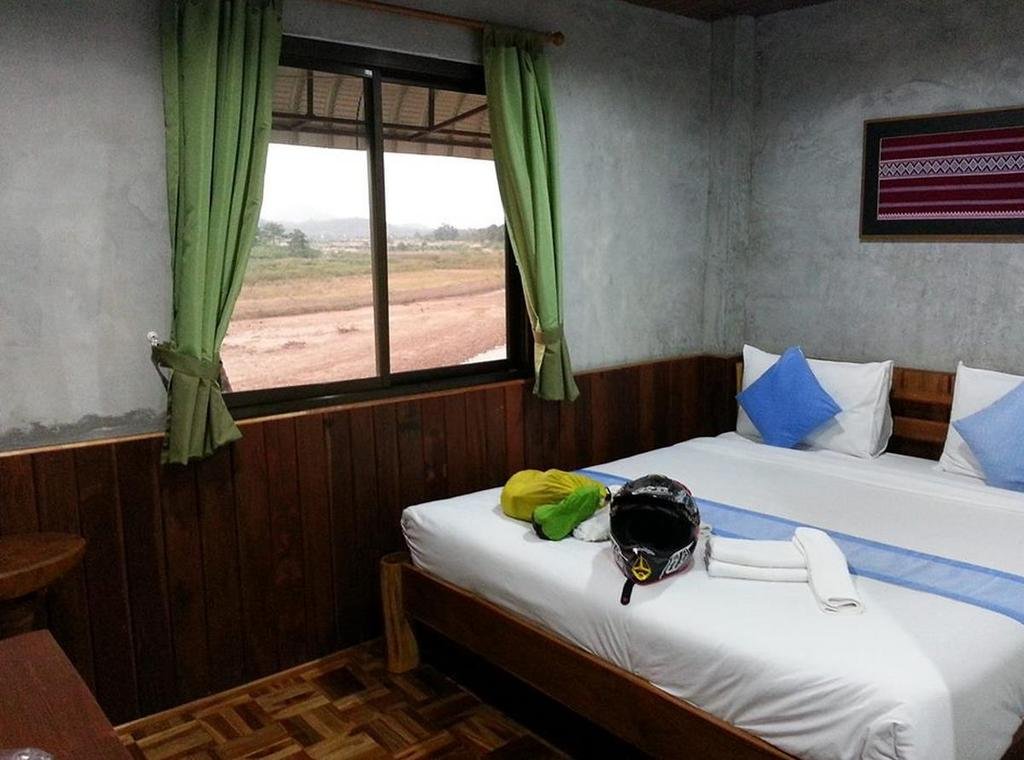
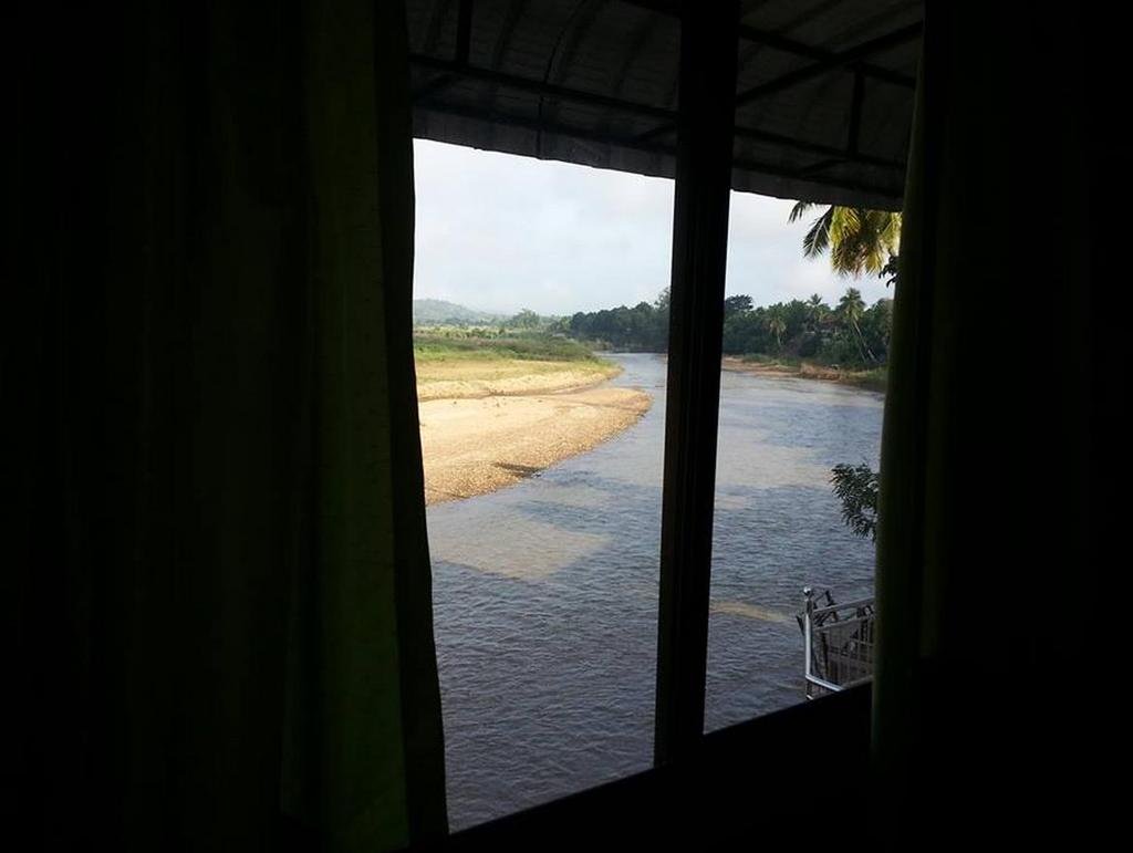
All going well and we manage to link from Omkoi all the way through to R 105 via a northern route, a hugely successful day. Enough daylight left, we scoot north to Mae Sariang for a night in the fabulous Good View GH, 600 Bht a bargain, right on the river.


good view gh.jpg


good view gh view.jpg
 
The next day, there was a particular village we wanted to spend the night in and having Mai with us we'd be able to find out about the river crossing that links to R 1267.


Entering the Mae Ngao National Park near the Sop Moei region, there was a flurry of activity clearing the concrete section


10775101283_2853aed86e_b.jpg


We thought it might be due to the rainy season just finishing, we later found out that it was because the Thai Princess was arriving in a couple of days by helicopter and they needed the road usable for her team and supporters.
 
Rafting on the Mae Nam Ngao looks interesting and those rafts might be able to get a motorcycle across the river


10775049024_acbdd84f13_b.jpg


We found out from the locals that the yellow crop was soy beans. It had been heavily promoted as crop in the area to try give them an alternative income source from illegal logging.


10775032984_a555101a5f_b.jpg


An expensive suspension bridge had been built so that the soy bean crop could easily be transported across the Mae Ngao river


10775089503_eabb17b074_b.jpg


Looks like this was to feed the buffalo


10775094913_6113888a3e_b.jpg


10775073484_a42681e879_b.jpg
 
We got to the village on the Mae Nam Ngao, where it links to R 1267 on the western side, they told us that the river is only crossable by motorbike from late December to the end of February and even then motorcycles have to be carried across, good to finally understand the situation there.
 
Back
Top Bottom