Captain_Slash
Community Manager
- Joined
- Jun 28, 2011
- Bikes
- BMW 310GS Honda Wave 125 Honda MSX 125
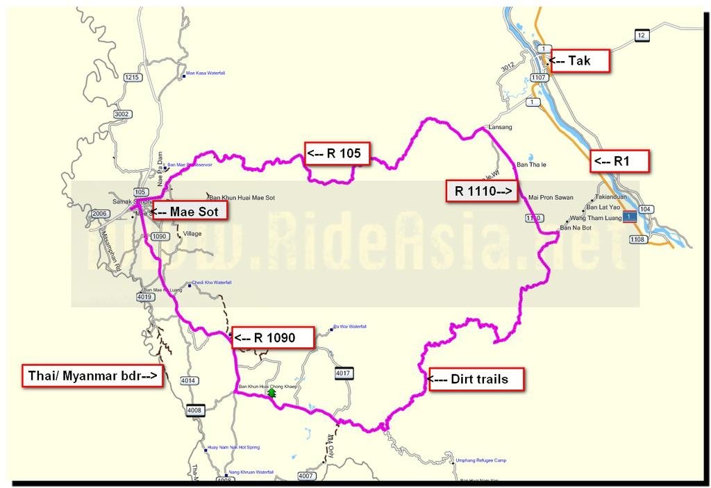
The route 105, 1108, 1110, 1090
Total distance 235 km


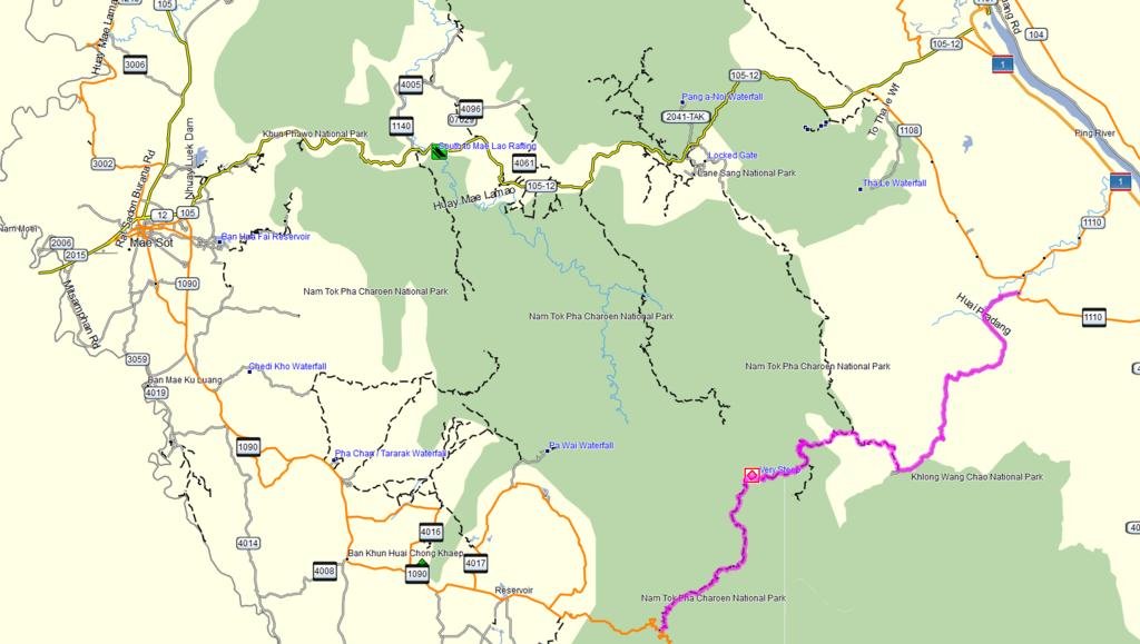
Todays trip was supposed to see how far the track went heading south that I part rode back in december, I am linking up with it via another dirt track off the 1110


This twisty unnumbered asphalt road that goes off the 1110 is one that I rode a few years back on the Phantom and I dont remember it being as potholed back then as it is now

In places its good but in others it aint


I reach a village and here I see fuel sold from a handpump


I head north out of the village and dirt begins almost immediately at N16.56149 E099.06313


Its great scenery pretty much all day today


The track splits but the Garmin map shows the track going most of the way to the track I was on before


As I go under tree cover the track no longer shows on the GPS but I have the track I need in front of me and within 2 km


I emerge back into the sunshine and quickly join up with the track I was on before

This was my turnaround point back in december where the guy who came along on the bike held his gun up, saluted and pointed on making me think there was possibly an army camp further along.
Beddhist commented that Google earth showed this track finishing at what looked like a compound so that was what I was expecting to find


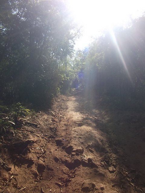
Thankfully the water and a lot of the mud has dried up since last month but its still slippery under the trees with deep ruts and a first gear job for a while

Out in the sunshine at least its dry and rutted

A small water crossing here


I reach a fork in the road, to the left is where the GPS shows the track going and the track to the right doesnt appear on the map.
This guy tells me the left track goes to Tak, I do a salute and hold a pretend gun and he points to the right, I ask Mae Sot, he says yes and so to the right it was

I was expecting the track to veer northwards but it went west and south which was puzzling to start with, at another fork I take the right


I stop at the river crossing as I dont see any tracks going through and here I turn round and ride back about 2 km to try that other fork out but it just looped round in a circle so it was back to the river


These people lived by the river and confirmed Mae Sot was this way so I rode through the water and carried on

Just the other side of the river is a Police camp at N16.56051 E098.96862 where they didnt want any photos taken but they also confirmed this way goes to Mae Sot


I now reach the truly difficult part and try to get up it without stopping, I get so far then keep stalling as the KLX is getting bogged down with the steepness combined with the loose surface, rocks and tree roots.
I finally get stuck but luckily for me there are four Policemen a bit further up who come to my aid and we get the KLX going again, then I stall it again on another part, slide backwards and drop the KLX but again they helped me and the KLX up and finally I manage to finish this tough section.
A lower gearing would definitely be a bonus here
This is a difficult section and I would not want to do it alone again, in fact I didnt do it alone as without their help I might have had to have turned back


Finally I reach the peak and its 1156 metres high


Its beautiful up here

I pass some cattle then meet this man


Thankfully that one swings open, if it had needed dismantling it would have been as theres no way I want to return the way I have come.
At this gate I notice a track appearing on my GPS in the distance and can see where this track should go to because at the moment I am not riding on any showing track.
I am pleased to see it will take me to the 1090 so at long last I will have found the route across that links up.
1 or 2 km before this gate there was a track leading off northwards and I am wondering if that joins up with any of my other tracks


I reach another Police post

In the distance I can see the road going out from the village that I am heading towards and making its way back to the 1090, its a road I mapped last year


At the edge of the village


Now back in the village I visited last year and here its a stop for water and some peanuts


This one went all shy when the camera came out

Kids will be kids, they have just tipped the litter bin upside down and are now busy picking the litter up and putting it back in the bin


Looking back to where I have just rode down, although it doesnt show in the photo I can see with my eyes the Police post


Now to ride to the 1090 along this track that has these concrete strips in places and is dirt in others


Just past here I reach the 1090 and ride home after a brilliant find, dirt finishes as I reach the 1090

A vegetarian pizza at Casa Mia for 130 Baht
Get the gdb file from my website Ride reports - Thailand, Malaysia and UK
Total distance 235 km


Todays trip was supposed to see how far the track went heading south that I part rode back in december, I am linking up with it via another dirt track off the 1110


This twisty unnumbered asphalt road that goes off the 1110 is one that I rode a few years back on the Phantom and I dont remember it being as potholed back then as it is now

In places its good but in others it aint


I reach a village and here I see fuel sold from a handpump


I head north out of the village and dirt begins almost immediately at N16.56149 E099.06313


Its great scenery pretty much all day today


The track splits but the Garmin map shows the track going most of the way to the track I was on before


As I go under tree cover the track no longer shows on the GPS but I have the track I need in front of me and within 2 km


I emerge back into the sunshine and quickly join up with the track I was on before

This was my turnaround point back in december where the guy who came along on the bike held his gun up, saluted and pointed on making me think there was possibly an army camp further along.
Beddhist commented that Google earth showed this track finishing at what looked like a compound so that was what I was expecting to find


Thankfully the water and a lot of the mud has dried up since last month but its still slippery under the trees with deep ruts and a first gear job for a while

Out in the sunshine at least its dry and rutted

A small water crossing here


I reach a fork in the road, to the left is where the GPS shows the track going and the track to the right doesnt appear on the map.
This guy tells me the left track goes to Tak, I do a salute and hold a pretend gun and he points to the right, I ask Mae Sot, he says yes and so to the right it was

I was expecting the track to veer northwards but it went west and south which was puzzling to start with, at another fork I take the right


I stop at the river crossing as I dont see any tracks going through and here I turn round and ride back about 2 km to try that other fork out but it just looped round in a circle so it was back to the river


These people lived by the river and confirmed Mae Sot was this way so I rode through the water and carried on

Just the other side of the river is a Police camp at N16.56051 E098.96862 where they didnt want any photos taken but they also confirmed this way goes to Mae Sot


I now reach the truly difficult part and try to get up it without stopping, I get so far then keep stalling as the KLX is getting bogged down with the steepness combined with the loose surface, rocks and tree roots.
I finally get stuck but luckily for me there are four Policemen a bit further up who come to my aid and we get the KLX going again, then I stall it again on another part, slide backwards and drop the KLX but again they helped me and the KLX up and finally I manage to finish this tough section.
A lower gearing would definitely be a bonus here
This is a difficult section and I would not want to do it alone again, in fact I didnt do it alone as without their help I might have had to have turned back


Finally I reach the peak and its 1156 metres high


Its beautiful up here

I pass some cattle then meet this man


Thankfully that one swings open, if it had needed dismantling it would have been as theres no way I want to return the way I have come.
At this gate I notice a track appearing on my GPS in the distance and can see where this track should go to because at the moment I am not riding on any showing track.
I am pleased to see it will take me to the 1090 so at long last I will have found the route across that links up.
1 or 2 km before this gate there was a track leading off northwards and I am wondering if that joins up with any of my other tracks


I reach another Police post

In the distance I can see the road going out from the village that I am heading towards and making its way back to the 1090, its a road I mapped last year


At the edge of the village


Now back in the village I visited last year and here its a stop for water and some peanuts


This one went all shy when the camera came out

Kids will be kids, they have just tipped the litter bin upside down and are now busy picking the litter up and putting it back in the bin


Looking back to where I have just rode down, although it doesnt show in the photo I can see with my eyes the Police post


Now to ride to the 1090 along this track that has these concrete strips in places and is dirt in others


Just past here I reach the 1090 and ride home after a brilliant find, dirt finishes as I reach the 1090

A vegetarian pizza at Casa Mia for 130 Baht
Get the gdb file from my website Ride reports - Thailand, Malaysia and UK


