Captain_Slash
Community Manager
- Joined
- Jun 28, 2011
- Bikes
- BMW 310GS Honda Wave 125 Honda MSX 125
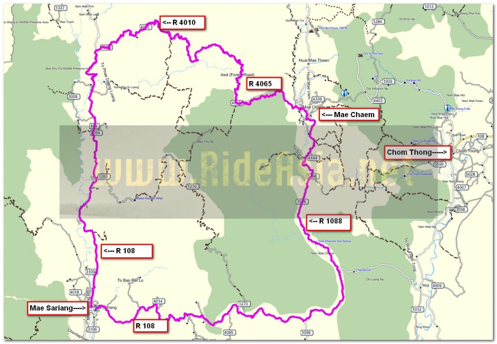
The route 108, 4009, 4010, 4065, 1088,
Total distance 307 km

Riding north along the 108 and although I didnt leave town until 9.30 it was a very cold ride, the pullover under my airflow jacket wasnt enough so the water/windproof liner went in as well, that solved the problem


I take a right onto the 4009 to ride to Mae Chaem on some dirt later on


A few potholes in places but some good curves too


A good surface now with stunning scenery all the way to Mae Chaem


I noticed these fuel pumps in every village so no worries about getting fuel


The paved surface finished and turned to dirt at N18.34.735 E098.08.317


There was the odd bit of concrete here and there but mainly in villages and nothing much


The track gets a bit rougher and steeper from here


A bit of everything in this picture, smoke from fires, water being sprayed for irrigation plus its a bit hazy too

The track is now described as a 4WD forestry track, its loose rocky and steep but the KLX doesnt miss a beat


A few bikes come down, some two up with rucksacks and making it look easy


The dusty track I have just rode up


Over 1.5 km high now


Now for a ride through the trees and its getting cold again at this altitude


After 27.5 km according to my speedo the road turns to Asphalt at N18.32.811 E098.13.981 but its not a good surface for a while


Now on the descent into Mae Chaem, I was thinking I would be there by about 12.30 and rolled in at 2.30, it was a longer ride than I was expecting.
I called in for fuel, 171 km since I filled up in Mae Sariang and the fuel light still wasnt on at Mae Chaem, it took 4.9 litres so that worked out at 35 kpl even with the off road section, no complaints about the economy of the KLX from me

I take the 1088 south out of Mae Chaem and notice this reservoir that isnt visible riding north wards on it as I always do

A brown water reservoir by the look of it

Almost full

One final photo of the Mae Chaem river then its a straight ride back to Mae Sariang

Its a Moukata for food tonight at N18.09.657 E097.56.293

Lots of bacon and lots of cabbage

Finished off with ice cream, all for 108 Baht
You can get the gdb file from my website here … http://www.captainslash.com
Total distance 307 km

Riding north along the 108 and although I didnt leave town until 9.30 it was a very cold ride, the pullover under my airflow jacket wasnt enough so the water/windproof liner went in as well, that solved the problem


I take a right onto the 4009 to ride to Mae Chaem on some dirt later on


A few potholes in places but some good curves too


A good surface now with stunning scenery all the way to Mae Chaem


I noticed these fuel pumps in every village so no worries about getting fuel


The paved surface finished and turned to dirt at N18.34.735 E098.08.317


There was the odd bit of concrete here and there but mainly in villages and nothing much


The track gets a bit rougher and steeper from here


A bit of everything in this picture, smoke from fires, water being sprayed for irrigation plus its a bit hazy too

The track is now described as a 4WD forestry track, its loose rocky and steep but the KLX doesnt miss a beat


A few bikes come down, some two up with rucksacks and making it look easy


The dusty track I have just rode up


Over 1.5 km high now


Now for a ride through the trees and its getting cold again at this altitude


After 27.5 km according to my speedo the road turns to Asphalt at N18.32.811 E098.13.981 but its not a good surface for a while


Now on the descent into Mae Chaem, I was thinking I would be there by about 12.30 and rolled in at 2.30, it was a longer ride than I was expecting.
I called in for fuel, 171 km since I filled up in Mae Sariang and the fuel light still wasnt on at Mae Chaem, it took 4.9 litres so that worked out at 35 kpl even with the off road section, no complaints about the economy of the KLX from me

I take the 1088 south out of Mae Chaem and notice this reservoir that isnt visible riding north wards on it as I always do

A brown water reservoir by the look of it

Almost full

One final photo of the Mae Chaem river then its a straight ride back to Mae Sariang

Its a Moukata for food tonight at N18.09.657 E097.56.293

Lots of bacon and lots of cabbage

Finished off with ice cream, all for 108 Baht
You can get the gdb file from my website here … http://www.captainslash.com


