Captain_Slash
Community Manager
- Joined
- Jun 28, 2011
- Bikes
- BMW 310GS Honda Wave 125 Honda MSX 125
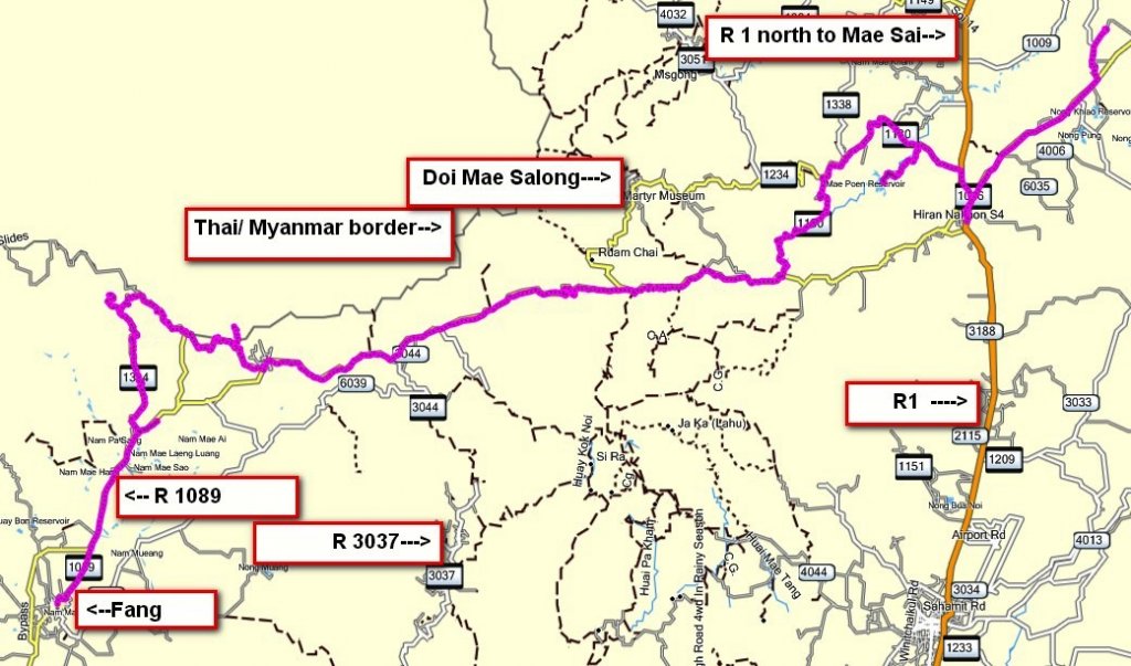
The route 1089, 1314, 1130, 1016, 4010
Total distance 164 km
This ride took place on 7th december

I take the 1089 to Mae Ai then its a left to ride up along the border on the 1314


A good twisty road


I take a turn for the Tad Luang waterfall and have to ride this unpaved track for about 200 metres

I shouldnt have bothered as I could only see this between the trees

Back on the 1314 and some views from the Thai Army camp at the top


I dont know what it says but theres a dirt track heading in the direction of the border


I ride down the dirt track for about 200 metres

This guy is there with his strimmer


Further along the 1314 I take a left onto a new dirt road that looks like its is being prepared for a paved surface that goes to this Thai Army camp at N20.04.941 E099.20.340


The road under construction


I ride back to the 1314 and this is the sign at the entrance to the Army Camp


I get back to the 1089 in Tha Ton then further east I take a left onto the 1130 to explore this new road for me

Its steep, narrow and twisty


I take a right to visit the Mae Phen reservoir

This track goes through the water but I have no desire to ride through


This Lady walks through carrying her load

From here I ride to the other side of Mae Chan to visit a friend
You can get the gdb file from my website here … http://www.captainslash.com
Total distance 164 km
This ride took place on 7th december

I take the 1089 to Mae Ai then its a left to ride up along the border on the 1314


A good twisty road


I take a turn for the Tad Luang waterfall and have to ride this unpaved track for about 200 metres

I shouldnt have bothered as I could only see this between the trees

Back on the 1314 and some views from the Thai Army camp at the top


I dont know what it says but theres a dirt track heading in the direction of the border


I ride down the dirt track for about 200 metres

This guy is there with his strimmer


Further along the 1314 I take a left onto a new dirt road that looks like its is being prepared for a paved surface that goes to this Thai Army camp at N20.04.941 E099.20.340


The road under construction


I ride back to the 1314 and this is the sign at the entrance to the Army Camp


I get back to the 1089 in Tha Ton then further east I take a left onto the 1130 to explore this new road for me

Its steep, narrow and twisty


I take a right to visit the Mae Phen reservoir

This track goes through the water but I have no desire to ride through


This Lady walks through carrying her load

From here I ride to the other side of Mae Chan to visit a friend
You can get the gdb file from my website here … http://www.captainslash.com


