Captain_Slash
Community Manager
- Joined
- Jun 28, 2011
- Bikes
- BMW 310GS Honda Wave 125 Honda MSX 125
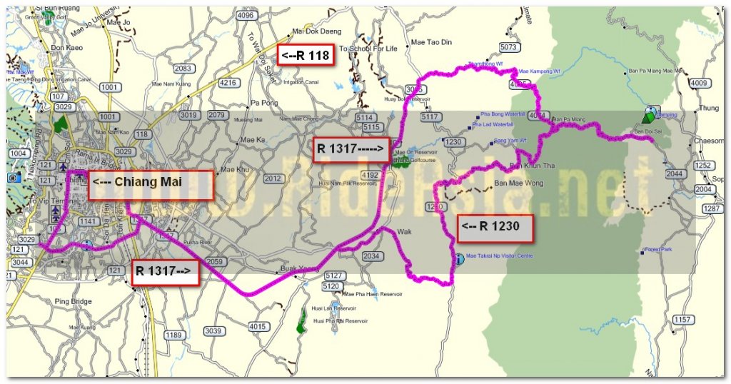
The route 1317, 1006, 1229, 1230, 4074, 2044, 4005, 3005,
Total distance 181 km

A shot from the 1006


Now from the 1230 where sand is being taken from the Nam Mae tha


Now to enjoy the asphalt section of the 1230

The unpaved section starts at N18.46.131 E099.17.353 and finishes at N18.47.290 E099.17.998


The view point at the top


This short off road bit is not too difficult

Now on the narrow road to Ban kunta


The repairs have been finished and it looks a lot better now

A twisty narrow road with no photo opportunities to get scenery shots from

The village name is still there


Some friendly animals live here

I take a dirt track that starts at N18.47.772 E099.20.982 and today I ride uphill on a dry but quite steep track unlike novembers trip when I rode down and it was wet and slippery in places


Its a fun ride and at the top instead of turning left onto a concrete road I turn right to stay on dirt and try out a track that I have not been on before


A very small water crossing


After about 1 km I ride through a small village but see no one about

Out the other side of the village and its a steep uphill climb


I can see some scenery now


This chap confirms the road goes through to Chae Hom


There are a couple of turnings to my right but I keep to the left, I am riding blind as none of these tracks are showing on my GPs maps


Now on a steep downhill bit


Theres a concrete strip running down this bit which is useful as I dont have to worry about locking the wheels up


This bridge rattled a bit as I rode over


A pleasant little jaunt through here

The road turns to paved at N18.49.251 E099.22.927

I take a right upon reaching the 4074 to ride towards Chae Hom


After a while I turn round to ride back along the 4074

All the water crossings are still flowing over the road


A baked ziti at Pizza N Pasta for 119 Baht, very filling and tasty
You can get the gdb file from my website here … http://www.captainslash.com
Total distance 181 km

A shot from the 1006


Now from the 1230 where sand is being taken from the Nam Mae tha


Now to enjoy the asphalt section of the 1230

The unpaved section starts at N18.46.131 E099.17.353 and finishes at N18.47.290 E099.17.998


The view point at the top


This short off road bit is not too difficult

Now on the narrow road to Ban kunta


The repairs have been finished and it looks a lot better now

A twisty narrow road with no photo opportunities to get scenery shots from

The village name is still there


Some friendly animals live here

I take a dirt track that starts at N18.47.772 E099.20.982 and today I ride uphill on a dry but quite steep track unlike novembers trip when I rode down and it was wet and slippery in places


Its a fun ride and at the top instead of turning left onto a concrete road I turn right to stay on dirt and try out a track that I have not been on before


A very small water crossing


After about 1 km I ride through a small village but see no one about

Out the other side of the village and its a steep uphill climb


I can see some scenery now


This chap confirms the road goes through to Chae Hom


There are a couple of turnings to my right but I keep to the left, I am riding blind as none of these tracks are showing on my GPs maps


Now on a steep downhill bit


Theres a concrete strip running down this bit which is useful as I dont have to worry about locking the wheels up


This bridge rattled a bit as I rode over


A pleasant little jaunt through here

The road turns to paved at N18.49.251 E099.22.927

I take a right upon reaching the 4074 to ride towards Chae Hom


After a while I turn round to ride back along the 4074

All the water crossings are still flowing over the road


A baked ziti at Pizza N Pasta for 119 Baht, very filling and tasty
You can get the gdb file from my website here … http://www.captainslash.com


