Another day - Another Trip

Lone Rider

Blokes Who Can
Joined
Jan 29, 2011
Location
Chiangmai
Bikes
4 Wheels
Another day - Another trip

I was in need of additional information on role of the Kuo Minh Tang (KMT) in guarding road construction crews so what better to do then just get in the car and try to find it. However, there were quite a few interesting things to see along the way so in the end it became more of a "Wat" trip rather than a "War" trip.

The route taken - a two day trip with an overnight stay at the "Little Home" guesthouse in Doi Mae Salong
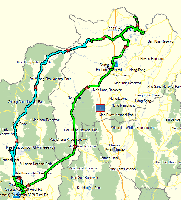
The Route.PNG

First stop along the way to the north was the Mae Taeng area west of Rd. 107 - an area where I had not been for a long time. I had a look around and found several temples which seemed to be interesting. Mu first stop was a Meditation Temple (N19.16458 E98.91237) at the end of Rd 5089 close to the Mae Taeng Irrigation Project. Although there were lots of visitors, it was otherwise a low-key affair so not really interesting. While on my way back I spotted a few stupa's to the west belonging to Wat Thung Luang (N19.15404 E98.93170) and Wat Nong Bua, also known as Wat Muangnipphan (N19.15202 E98.93688).

Wat Thung Luang
IMG_5015.jpg


3e934e9c-471b-4dff-9fdd-4a1592f5a709.jpg


IMG_5013.jpg


IMG_5021.jpg


Wat Nong Bua - another meditation temple
IMG_5027.jpg


Close by is Wat Phrathat Si Wichai (N19.14617 E98.91953) - apparently dedicated to Khru Ba Siwichai also know as the "Developer Monk" for the many temples, schools, roads, etc he managed to establish - see also The Buddhist Saint of Northern Thailand: Kruba Sriwichai

IMG_5041.jpg


Lots of well fed and healthy looking dogs at the temple
IMG_5039.jpg


IMG_5036.jpg


IMG_5031.jpg


The view from the temple
IMG_5033.jpg


North of Fang another stupa stuck out of the woods which I call the "Chrystal Temple" for lack of a better name - again one of these temples where money is no problem (coordinates N19.97489 E99.22932)

IMG_5052.jpg


Inside the stupa is the "Chrystal" stupa and lots of fancy decorations
IMG_5055.jpg


IMG_5056.jpg


IMG_5050.jpg


IMG_5057.jpg


IMG_5051.jpg


A meditation area with a solitary nun
IMG_5045.jpg


IMG_5058.jpg


A fancy stainless steel tree
IMG_5046.jpg


Lots of new kuti's for the monks being constructed all in the shape of Lotus Flower buds
IMG_5061.jpg


The view from road 1089 with more kuti's being constructed to the east of the temple
IMG_5062.jpg


More to follow later
 
Great pictures Auke some places there i never knew existed, thanks for sharing.
 
Looks like you should do an E-Book Mr.K, so much unique information even over the past couple of weeks!!!!:DD
 
Awesome! Thanks for sharing. Stuff I've whizzed right by and never even known was there...
 
PART 2 - After the opulence of the "Chrystal Stupa" it was time for a bit more down to earth and in my opinion closer to the real Buddhist principles with a visit to Wat Phrathat Doinamkhang (N20.01924 E99.25422) or rather its stupa (N20.02012 E99.25164) which is located on a mountain ridge

The Stupa and Buddha statues of Wat Phratat Doi Nam Kang
IMG_5073.jpg


IMG_5074.jpg


From this location you have tremendous views over the valley to the south-east
IMG_5070.jpg


On the way back I saw a Burmese style temple and, as I had plenty of time, I had a quick look. The temple is called Wat Mueang Nong
IMG_5077.jpg


I must admit that, when I see somewhere a temple or stupa sticking out of the woods, I feel an urge to have a look and so, when I was cruising along the Kok river on my way to Doi Mae Salong, there was another one calling out to me. After several failed attempts to find the temple I finally managed to find the right track up the mountain to another wat for which I do not know the name. Opposite the Thanathon Orange Plantation turn south, cross the Kok river and follow road 3023. Turn north at N20.04078 E99.40335 and follow the track up the mountain (quite a few birds along this track in the bamboo forests).

IMG_5091.jpg


IMG_5079.jpg


IMG_5080.jpg


Again very nice views to the west (Wat Tha Thon also known as Wat Luang with several buddhas and stupas like the Phra Boromthat Rajamonk Klajarn Samanachant Chedi Kaew along the road up the mountain) and the orange plantations to the north
IMG_5082.jpg


IMG_5085.jpg


While there, the sky became darker and darker and although the wind picked up in speed quite a bit, it stayed dry further along my trip
IMG_5087.jpg


In Doi Mae Salong I had hoped to meet a guy who was supposed to know quite a bit about the time when they were hired to protect the road construction crews who were building road 1155. The Kuo Minh Tang guards lost 156 of its people while protecting the road builders on a stretch of less than 20 kilometer to the southern end of Rd. 1155. Somehow the guy did not show up and my contact also could not get into touch with him. Anyway, as I was there I had another look at the Chinese Martyr Museum

A picture of the two generals who found their home in the north of Thailand. On the left is General Lee We Huan of the 3rd Army of the Kuo Minh Tang and on the right General Tuan Shi Wen of the 5th Army of the Kuo Minh Tang (see also an earlier trip report - http://www.rideasia.net/motorcycle-...ports/3787-up-north-another-one-day-loop.html)
IMG_5092.jpg


IMG_5118.jpg


While his Mom was busy trying to sell tea to the tourists at the Martyrs Museum, this young guy tried to get his slightly older sister to join him on a joy-ride on Mom's Fino but he did not succeed as his sister was more interested in eating her crisps.
IMG_5119.jpg


More to follow - first have to figure out why Photobucket had decided to show all the pictures of Day 2 in Landscape mode even though quite a few were shot in Portrait mode
 
I have the same problem sometimes, Auke. I even wrote to them and asked if others had reported the problem and they assured me it surely must just be my computer.
 
PART 3 - After a quiet night at the "Little Home" Guesthouse (400 Baht a night for a bungalow) I had a walk around in the village and a look at the morning market at Doi Mae Salong

Early morning view over the mountains
IMG_5127.jpg


A new stupa inder construction to the east of Doi Mae Salong
IMG_5128.jpg


There are still many road signs in Chinese here as this was the head quarters of the 5th army of the KMT.
IMG_5129.jpg


IMG_5131.jpg


IMG_5133.jpg


IMG_5135.jpg


IMG_5140.jpg


IMG_5145.jpg


IMG_5142.jpg


At the site of the new stupa a small shrine has been finished but they are still busy working on the stupa itself (located in Ban That at N20.14785 E99.66621)
IMG_5148.jpg


IMG_5149.jpg


IMG_5153.jpg


My next stop was the new commercil harbor of Chiangsaen. Previously all the loading and unloading of cargo from China, Laos and Myanmar was done in the city of Chiangsaen but this caused many problems with traffic so a new port was built near Ban Sop Kok just east of the site there the Kok River joins the Mekong (coordinates N20.24137 E100.13828). Most of the carge is now handled here but there are still some activities going on in Chiangsaen itself

Three CRF's and three PCX'es ready to leave Thailand by boat to another country.
IMG_5188-Copy.jpg


Loading and unloading of cargo at the commercial port
IMG_5161.jpg


IMG_5157.jpg


The office of the harbor master
IMG_5160.jpg


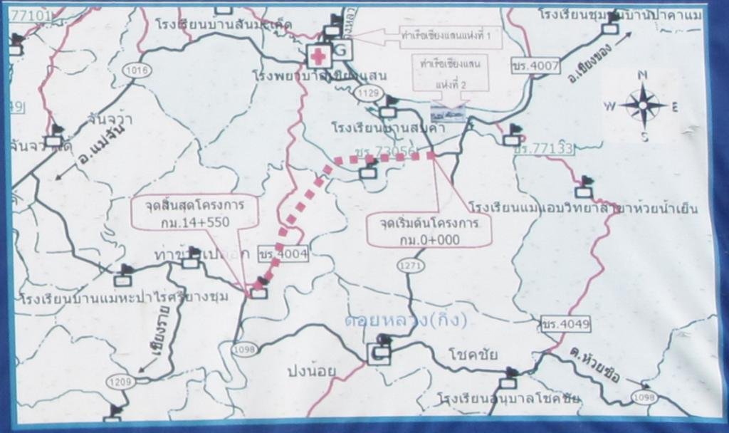
Close by the new harbor, a new road is being constructed which will provide a direct link between Rd. 1129 (at N20.22037 E100.13213) and Rd. 1098 (see the blow-up of the map for where the road will link)
IMG_5165.jpg


New Road.jpg

Along the road there are quite a few ancient temples from the Chiangsaen era and I stopped to have a look at Wat Phratat Song Phi Nong (20.24561 E100.11935) as it is not on the normal "temple circuit"

IMG_5166.jpg


IMG_5168.jpg


IMG_5171.jpg


While taking a detour along Rd 1209 so I would miss the boring Highway 1 I was passing by Wat Muen Phutta Mettakhunaram which is basically an educational facity for Thai and Chinese monks (coordinates N20.16382 E99.99554)

IMG_5192-Copy.jpg

IMG_5193-Copy.jpg

IMG_5194-Copy.jpg

IMG_5197.jpg

IMG_5198.jpg


Final stop at Charin with a picture of some guys fishing in the river instead of the usual "coffee and pie" picture
IMG_5254-1.jpg
 
I have the same problem sometimes, Auke. I even wrote to them and asked if others had reported the problem and they assured me it surely must just be my computer.

Don't know what happened as I followed my normal procedure - batch downsizing the pictures using Irfan View and then uploading them to Photobucket. Normally never a proble but now suddenly all pictures were shown in landscape mode.

In the end I did a new Batch Resize but now omitting/deleting all the EXIF and IPTC data of the downsized picture and uploaded them again and luckily they now showed up in proper Landscape and Portrait mode
 
Thank you soo much for taking the time to share your journey with us Auke.

This country has so many gems tucked away.

Ally
 
Back
Top Bottom