Another day - Another Trip this time to the south of Laos

Lone Rider

Blokes Who Can
Joined
Jan 29, 2011
Location
Chiangmai
Bikes
4 Wheels
Another day - another trip

Hadn't been to the south of Laos for some time so when I saw a few free days coming up I made up my mind to have another look eventhough it takes a day and a half to get there and the same amount of time to get back to base in Chiangmai. No real fixed plans for the trip other than that I needed to update some of the district "capitals" for my Laos GPS map and re-visit some of the waterfalls I would pass en-route. Had a long and boring trip to Mukdahan to cross the Mekong to Savannakhet from where I was to head further south.

While crossing the "Friendship Bridge 2" the sky did not look very good in the south of Laos and the next week or so that was something I would see almost every morning when checking the weather before heading of on the next leg of my trip
IMG_8515.jpg


So, after a faily efficient border crossing on both sides I headed south along Rd 13 and then turned east at Ban Kong Koum 5 to Saravan along Rd 15. The upgrading from a dirt road to paved is now almost finished and Rd 15 is now basically all paved from Rd 13 via Saravane, Ta-Oy and Samuoi all the way to the Vietnam border at the Lay-Lay border crossing where it links with Highway 14 in Vietnam.

IMG_8522.jpg


The new bridge over the Xe-Done river with next to it the old concrete river crossing and the old ferry which was only used when the river was to high to cross safely over the concrete crossing
IMG_8524.jpg


IMG_8523.jpg


IMG_8525.jpg


As Rd 15 is now paved, I had plenty of time to reach Saravan where I was planning to stay the night. So time to "fiddle around and explore the country side" and in Vapy district there are plenty of rapids in the rivers so off to the north to the confluence of the Xe-Set and Xe-Done rivers.
IMG_8531.jpg


IMG_8532.jpg


IMG_8534.jpg


A new development at the Kaeng Khou rapids - not sure if this will be a resort or if it will be used by the company which is constructing a dam for the the Xe-Set Kaeng-San Hydro Power Project just a bit up-stream from here.
IMG_8536.jpg


It was still quite early when I reached Saravan and as I find it a boring place to stay, I decided to head south for about 30 km. to spend the night at the Tad Lo falls

Most of the roadworks along Rd 1H from Saravan to the Tang Beng junction are now finished but some of the old bridges have not yet been replaced so watch out in particular during night time.
IMG_8537.jpg


The Tad Lo area was quiet with very few tourists around so I had basically the place to myself.

The Tad Hang Falls - there was quite a bit water flowing probably due to the rains they had over there during the last few days
IMG_8545.jpg


IMG_8540.jpg


Tad Hang during a very dry season (picture copyright by Stuart Edwards)
tat-lo_tat-hang.jpg


Farmer tending to his vegetable garden right next to the Tad Hang Falls
IMG_8541.jpg


The Tad Lo Falls
IMG_8548.jpg


IMG_8551.jpg


And more to the south the Tad Soung Falls (picture copyright by Ken Marshall) - did not go there as it was getting dark so just a few pictures taken by others
84243080.jpg


From the top of the Tad Soung falls you have nice views to the north (picture copyright by Thomas Pax)
62765044.jpg


Village life along the river at the end of the day
IMG_8546.jpg


Stayed the night at the Sipaseuth Gh right next to the bridge which is normally quite OK but this time it was awful probably due to being "out of the tourist season" and I had the worst "Khao Pat" I have ever had but at least the beer was ice-cold.

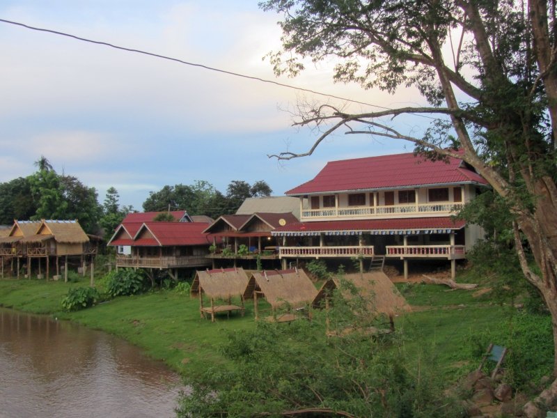
The Sipaseuth Gh and the Sailomyen Gh at the left
IMG_8544.jpg


To be continued: Tad Lo - Saravan - the old Kaleum district - Sekong
 
Amazing how much water is flowing for this time of year Auke.

Nice looking GH's from the outside, how much ?

IMG_8544.jpg
 
Amazing how much water is flowing for this time of year Auke.

Nice looking GH's from the outside, how much ?

View attachment 28954

Yes, the outside is nice and it has a direct view of the Tad Hang falls. Price per night was 80,000 Kip without breakfast and no Wifi but as I had a Lao Telecom SIM data package that was no problem. Must admit that the room had seen better times but that seems to be a general problem with preventive maintenance not high on the list of things to do to keep the business humming.
 
There is something about fast flowing waterfalls


Sent from my iPod touch using Tapatalk
 
Part 2 of "Another Day - Another Trip: - Tad Lo - Saravan - the old Kaleum district - Sekong

The next morning it was of to Ban Kengkouy or the old Kaleum district capital and a plan that I might head from the old to the new Kaleum district capital - Ban Vak - and from there to Dakcheung to Sekong but somehow during the day it became clear that my plan was a tad to ambitious or rather that the local conditions would be such that I would have to keep a visit to the new Kaleum and Dakcheung for later in the week. Heading north from Tad Lao to Saravane and from there to Ta-Oy things looked good - a nicely paved road all the way. But first I had a look at how deep the Xe Don river was at Saravane as this would be my alternative "escape" route if things did not work out as planned
Well, this truck went through without problems so my old truck should be able to get through as well
IMG_8558.jpg


Rd 15 from Saravane to Ta-Oy
IMG_3513.jpg


IMG_3514.jpg


IMG_3515.jpg


I had been to Ta-Oy on an earlier trip and had seen a camp which looked a bit "out of place" for Ta-Oy with fences, helicopter landing pads, etc. but very little going on. I asked the locals and they indicated that it had something to do with the American army searching for remains of people "missing in action or MIA"

IMG_3519.jpg


IMG3518a.png


Areial View of the Ta-Oy Base Camp in 2006 (Picture Copyright NAVFAC)
8696599497_bc8b490d1e.jpg


Once back home I did some research and found that this was the base for the "Joint POW/MIA Accounting Command". The Ho Chi Minh trail (Ho Chi Minh trail - Wikipedia, the free encyclopedia) was running through Sekong province and the trail has seen a lot of fighting. The US Air-force lost quite a few planes and personnel while trying to make trail un-usable to the Vietnamese and quite a few of its personnel was declared "missing in action". With two large hydro power projects planned in this area which will flood part of the Ho Chi Minh Trail coupled with the US policy of "no one left behind" the camp was established to aid their efforts of finding their MIA's before the area would be flooded. The camp is located on the south-eastern side of Ta-Oy (Coordinates N16.07311 E106.62656). This time I had a quick look again and although there was a bit more going on, it was still quiet. For those of you interested in these things there is more info and pictures at these sites:

Renovation of the Ta-Oy Base Camp
https://www.navfac.navy.mil/navfac_worldwide/pacific/news/2013_featur_articles/May1_NAVFAC_Pacific_Completed_Renovations_to_Base_Camp_in_Laos.html

Pictures of the camp and search activities by © KHAMPHA BOUAPHANH
JPAC Laos - Images | KHAMPHA BOUAPHANH

The search for Spooky 21
The Search for Spooky 21 | Politics Photos | McClatchy DC
ARLINGTON, Va.: Lost plane's crew returns from Laos — 48 years later | Local News | Merced Sun-Star


So back to my trip to Kaleum - During my previous trip I had seen a new road being constructed and I was told it was leading to Kaleum so this time I decided to go all the way to Kaleum and onwards

This is how the new road looked like in 2013
IMG_3537.jpg


Now the new road is signposted and the dirt is now covered by a layer of gravel but the views from the road are still very nice although the weather did not look very promising at times but to the south - the direction I was heading - there were blue skys so nothing to worry about
IMG_8561.jpg


IMG_8567.jpg


IMG_8573.jpg


IMG_8566.jpg


IMG_8574.jpg


The road builders have been busy cutting new roads through the mountains
IMG_8575.jpg


IMG_8576.jpg


My first view of the old Kaleum
IMG_8586.jpg


IMG_8584.jpg


IMG_8581.jpg


The river crossing for bikes to the new Kaleum some 30 km "as the crow flies" to the east
IMG_8580.jpg


Looking at the chocolate brown color of the water, they must have had quite a bit of rain as in March of this year the river looked like this (Photo copyright Tanya Lee)
sekong_river-compressed.jpg


The crossing for big trucks to the new Kaleum can be seen in the top right of the picture but later when I showed up the people started laughing and told me "No way - your truck can not" and while I can be rather stubborn I also know when to back of so Plan B would be it - taking the track to the west back to Saravan.
IMG_8587.jpg


Tracks going everywhere - most of these track lead to exploration sites for the coal mine
IMG_8593.jpg


One of the many river crossings between the "Old Kaleum" and Saravane
IMG_8595.jpg


Lots of mud along this bumpy track
IMG_8596.jpg


IMG_8597.jpg


Waiting so that one of the the local sales people with her shop on the backside of the bike can pass
IMG_8598.jpg


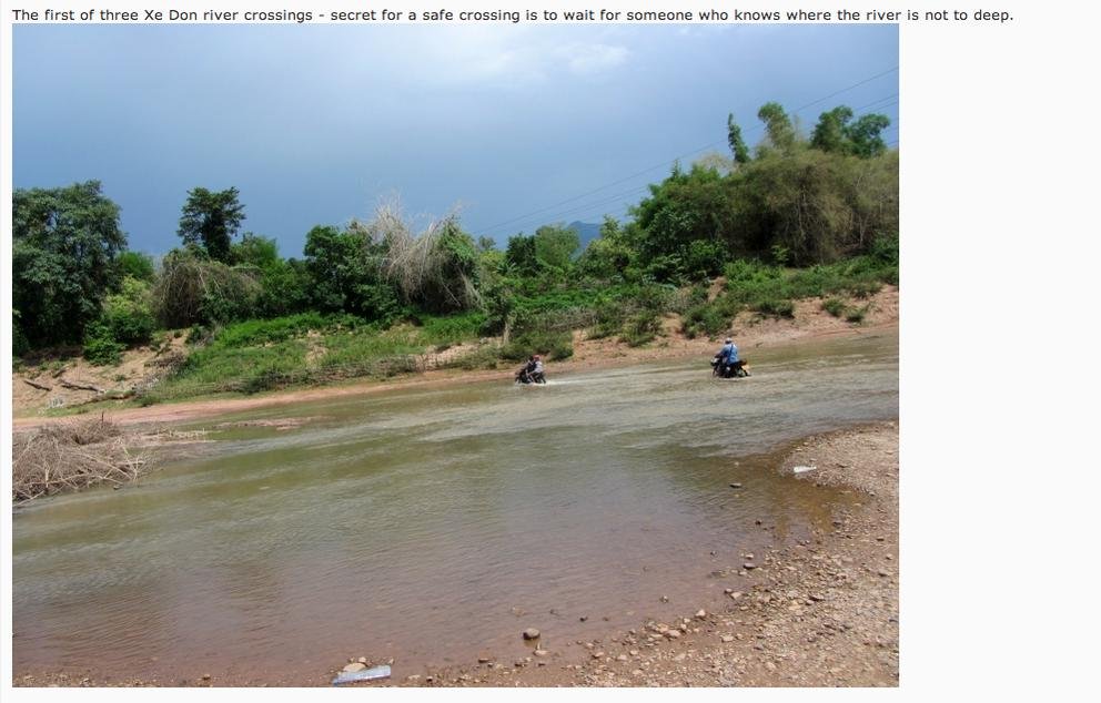
The first of three Xe Don river crossings - secret for a safe crossing is to wait for someone who knows where the river is not to deep.
IMG_8600.jpg


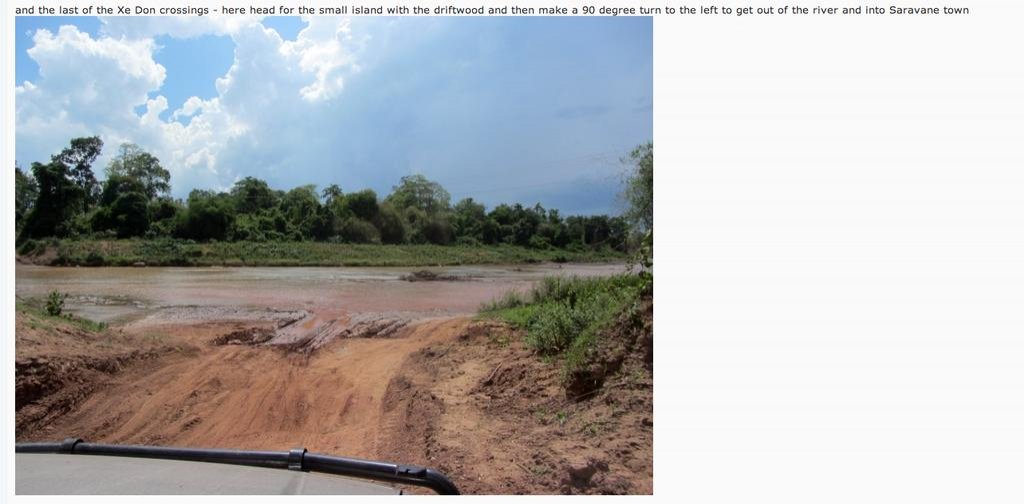
and the last of the Xe Don crossings - here head for the small island with the driftwood and then make a 90 degree turn to the left to get out of the river and into Saravane town
IMG_8601.jpg


===================================================================================================

Again for those interested in the reasons why the capital of Kaleum district is being moved

The view of the International NGO community
Mass Displacement and Underdevelopment on the Sekong River | International Rivers

The view of the Government of Laos in www.pasaxon.org.la (no longer on-line available so here is a copy)
*Causes of Kaluem District relocation*

Kaluem district is a mountainous area far from the center town of Sekong province 75 kilometers. Mountains cover 95% of the total area. There are 99% of indigenous people. This district is on a list of 47 poorest districts of the country. Kaluem District has 3,697.3 hectares and the population is 16,578 with 7,880 women. There are 58 villages and 7 village groups including 3 main ethnic groups such as Katoum, Krieng and Taoy. Their main occupations are growing circle upland rice, low land rice, crops. Raising animals is a secondary occupation. The villages are located distantly from each other. Mr. Khanti Sylavongsa, the Kaluem district governor reported that there are 4 main reasons why Kaluem is relocated to a new place.

1. Kaluem district is located in a reservoir area of Sekong 4 hydropower project. According to sixth and seventh 5 year socio-economic development plan of the government, the plan is the starting point of the project. Therefore, the government agreed to extract trees from the area. In addition, the same area is coal mining area project of an approved company by the government. This place contains a large volume of coal.

2. The district is risk for flood. Recently, there was a flood in 2009. Kaluem district had server impact from Ketsana storm. Government offices, houses of people, and farms were destroyed by a flash flood. This caused massive damage, especially the urban, which is an important place of the district. It was damaged more than the other places.

3. Kaluem has difficulty in terms of governance, development and poverty reduction as well as security. A 90% of Kaluem population lives along the Sekong River in the east. The old district is far away from other village groups, so it is difficult in terms of commute and future development.

4. The relocation project is considered for an obligation that the party and government have for local heroes contributing to country revolution.

This is a background of Kaluem district relocation. Mr. Khanti Sylavong, Kaluem district governor added that the relocation plan focuses on 11 activities to achieve 80% in the end of 2014. In early 2015, it will complete 100%. The plan is included transporting materials for construction such as iron, cement, stone, sand, bricks, wood, and so on in order to supply the two seasons. According to the plan, some people will be relocated first to settle in prepared location. Electricity and water supply is the most important activities that will be addressed as they are necessary for construction. The project is aimed for qualitative and timely construction to be as same as the saying “Building Kaluem to be a district model”.

Note by Lone Rider: The Sekong 4 hydro power project has been stopped now and it seems that the extremely well connected Phonesack Group which owns the coal mine in the area has won the battle with Region Oil (Russian company) which was going to build the Sekong 4 hydro power project. Region Oil was contractually obliged to contribute 36 million USD for the relocation of people and villages and I guess that they have being holding of paying this amount to the Government of Laos.

and some more background info about the HCM trail from a thesis on "The War for the Ho Chi Minh Trail" by Gregory T. Banner of the West Point United States Military Academy - took me a long time to read this
http://www.dtic.mil/dtic/tr/fulltext/u2/a272827.pdf


To be continued: Sekong to Attapeu and Pakxong
 
Thanks for the link Auke, some very interesting stuff and advice :D

Screen Shot 2014-05-19 at 08.21.10.jpg

Don't think i would fancy this one in a few months time.

Screen Shot 2014-05-19 at 08.21.52.jpg
 
Auke you keep finding and reporting interesting places


Sent from my iPod touch using Tapatalk
 
Great reading, thanks Auke
 
Thanks for the link Auke, some very interesting stuff and advice :D

View attachment 29002

Don't think i would fancy this one in a few months time.

View attachment 29003

Yep, in a few month time this probably will be a raging river and crossing will only be by canoe. And indeed even when you have seen someone crossing the river and just follow them you have to be careful. At the second crossing - sorry no pictures - I was about half way when the people who had just crossed the river by bike and whom I was following waved to me to go further south as the "line" they took to cross was suitable for bikes but probably to narrow for cars as cars normally in the middle of the river continue another 10-15 meters and then turn right instead of where the bikes turned right.
 
Sekong and on to Attapeu and Pakse

On my way from Saravan to Sekong I enjoyed the views over the plains with clouds covering part of the mountains

IMG_8603.jpg


IMG_8604.jpg


and just before I reached Selong the rain came down by the bucket full. Nice, as it really helped to cool down things (it had been stinking hot during the day) and the school kids loved it

IMG_8687.jpg


IMG_8688.jpg


In Sekong a quick trip to the ferry landing to ask people, who came from the direction of Vietnam, about the road conditions. The UXO-Lao staff just arriving from the Dakcheung area indicated that the unpaved roads were getting worse with the rains but that generally it was still manageable

IMG_8690.jpg


The sky to the east

IMG_8691.jpg


After a good night in Sekong (stayed at the Hongkham Hotel and had dinner at the Khamting Restaurant - Good food at this Vietnamese owned restaurant - Coordinates N15.34550 E106.72701) I continued my trip to Attapeu to update the map and re-visit some of the waterfalls along the road to Attapeu.

Close to Sekong along road 1-I there are two waterfalls (actually there are more but I only went to these two) - Tad Faek and Tad Se-Noi also known as Tad Hua Khon.

Tad Faek seems to be named after the "Ya Faek" grass which was growing on an island where now the waterfall is located. In 1968 the whole island was inundated and the island with the grass disappaeared completely The waterfall is 5-10 meters high and quite wide and is located at N15.24450 E106.75110

IMG_8704.jpg


IMG_8707.jpg


IMG_8712.jpg


From here it is small hop to the next waterfall - the Se-Noy falls named after the river but it is also known as the Tad Hua Khon falls as apparently the Japanese during the war beheaded several Lao soldiers here and threw their heads in the falls. The falls are located at N15.22945 E106.74623 quite close to the main road

IMG_8727.jpg


IMG_8728.jpg


IMG_8729.jpg


After all the waterwalls it was time for more dry conditions - Highway 18A which runs for about 100 km from Attapeu to the west and is all dirt at the moment - dry and dusty in the dry season while in the rainy season it is almost impassable as it is very muddy and often partly flooded. At the end of the dry season

IMG_8614.jpg


and Highway 18A during the rainy season (photos copyright The Bigfella)

035-2.jpg


045-1.jpg


It is supposed to change - something I said also some 2 years ago - but this time there were at least a contractor and a base camp at Mueang Sanamxai and a sign that things would be better in 2016

IMG_8611.jpg


After Mueang Sanamxai I went to Mueang Phouvong (south of Attapeu and mainly to update the GPS map) and from there to Mueang Xaisettha and Mueang Sanxai (both east of Attapeu mainly as a tourist)

The new Huay Prok bridge next to the old bridge in Ban Vanggnang (M. Phouvong)

IMG_8618.jpg


Making wood planks out of tree trunks

IMG_8619.jpg


Wat Luang built in 1578 in Ban Phamueang, M. Saysettha

IMG_8638.jpg


IMG_8625.jpg


The old temple is in bad shape as it was built out of un-fired clay blocks supported by wooden columns

IMG_8635.jpg


IMG_8636.jpg


IMG_8633.jpg


The Buddha statue at Wat Luang

IMG_8631.jpg


IMG_8630.jpg


A few hundred meters to the northeast you will find Wat Pha Saysettha also known as Wat Chulamany. This highly revered temple was built in 1577 and is best known as being the burial place of King Saysetthathirat with the ashes being buried under the Saysettha Stupa. The Saysettha Stupa and other building at the Wat

IMG_8640.jpg


IMG_8639.jpg


IMG_8642.jpg


From the temples to other things - a left over Russian Surface to Air Missile hiding behind a big board in Ban Pa-am, Mueang Sanxai

IMG_8648.jpg


IMG_8647.jpg


On the way to Pakse and, after all the touristic things, it was time for a bit of work again. The Xenamnoi 1 Hydro Power Plant along Rd. 16

IMG_8659.jpg


IMG_8661.jpg


IMG_8680.jpg


Never mind when you have a flat tyre - keep going. No spare tyre and as half of the rear wheels have been used for other things it is the end of the trip.

IMG_8684.jpg


IMG_8685.jpg


IMG_8686.jpg


Tad Xe Katam Tok along Rd 16 - the viewpoints is a bit difficult to find due to the ongoing road construction but when you see these trees with the spirit house you are at the right place (Coordinates N15.12623 E106.63806)

IMG_8669.jpg


IMG_8673.jpg


IMG_8671.jpg


Another picture of Tad Xe Katamtok when the trees at the viewpoint were smaller so you can see the whole waterfall which is over 100 meter high - photo copyright Adam Poskitt

tad-katamtok.jpg


Rd 16 is almost finished but not quite yet - the last cut through the mountain and here and there short sections which still need to be paved

IMG_8743.jpg


IMG_8731.jpg


Construction of the Xe-Pian - Xe Nam Noy Hydro Power Project has started

IMG_8770.jpg


Again heavy rain

IMG_8769.jpg


and the road is steaming once the rain stops.

IMG_8771.jpg


And within a short while we have again blue skies at the end of a long but nice trip through the south of Laos

IMG_8781.jpg
 
The old Wat was a very interesting find Auke, must put this area on my to-do list for next season.
 
Auke's RR's are awesome as he has so many GPS locations to share. Thanks Auke.

I wonder how active the search for the MIA's are lately? They were running pretty aggressively in Lao when Bush was President but the activity has seemed to taper off a bit now. Or maybe I just hear less and less of them nowadays.

I never heard of the Japanese be-heading some of their prisoners at the Sey-Noi waterfall, thanks for the grisly tidbit.

I can only imagine the backhanded shenanigans going on with all the dams. The Sekong 4 dam I'm sure has loads of it's own tales to tell. $36 million dollars to help in relocation......would be curious on how much of it actually makes it into redevelopment for the villagers.
 
Back
Top Bottom